John Saunders Plantation Site Archaeological ReportOriginally entitled: "The John Saunders Plantation Site Williamsburg Inn Golf Course (14th Green)"
Colonial Williamsburg Foundation Library Research Report Series - 1623
Colonial Williamsburg Foundation Library
Williamsburg, Virginia
1990
THE JOHN SAUNDERS PLANTATION SITE
Williamsburg Inn Golf Course
(14th Green)REPORT ON 1962 ARCHAEOLOGICAL EXCAVATIONS
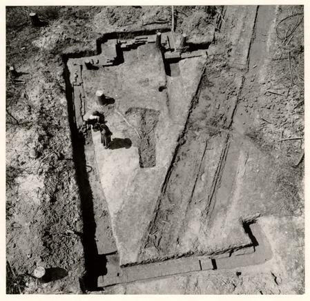 Frontispiece - Aerial view of Saunders foundations looking west. 62-GR-851
| Table of figures | |
| Introduction and Summary | 1 |
| History of the Site | 2 |
| Method of Excavation | 3 |
| The Structure | 3 |
| Landscaping | 6 |
| The Artifacts | 7 |
| Glass | 8 |
| Pottery | 8 |
| Metal objects | 9 |
| Animal remains | 9 |
| Conclusions | 9 |
| Acknowledgements | 12 |
| Appendix I: Excavation Register Series | 13 |
| Appendix II: Notes on John Saunders | 15 |
| Frontispiece | Aerial view of foundations |
| Figure 1. | Detail of Col. Desandrouin's map of 1781 |
| " 2. | Detail of the "Capitaine" map of 1781 |
| " 3. | Archaeological plan of Saunders site foundations |
| " 4. | East foundation |
| " 5. | Robbed north east corner of foundation |
| " 6. | Section through basement fill at north east corner |
| " 7. | South east corner of foundation |
| " 8. | Section through basement fill at south east corner |
| " 9. | Chimney foundation in course of excavation |
| " 10. | Interior of south corner of chimney |
| " 11. | South west corner and chimney |
| " 12. | North west corner |
| " 13. | Pottery and table glass |
| " 14. | Pottery, bottle glass and metal items |
| " 15. | Plan of site showing position on golf course |
The John Saunders Plantation Site
Archaeological Excavations of March-April, 1962
Introduction and Summary
In March 1962 Mr. Paul Buchanan, Supervisor of Architectural Research and Records and James M. Knight, Archaeological Engineer discovered that the proposed additions to the Williamsburg Inn golf course would cut through a plantation site shown on Col. Desandrouin's Map of 1781 whereon the property was identified as belonging to "Mr. Saunders." It was estimated that the plantation lay in the vicinity of the new Fourteenth Tee and, on the cartographic evidence, should comprise at least five buildings. Subsequently the examination of the "Capitaine Map" of 1781, another French military rendering of Williamsburg and its environs, showed only four buildings, but did show fence lines and an approach road leading off the Quarter Pass road to the south.
An examination of the estimated site by Messrs. Buchanan and James M. Knight resulted in the discovery of a brick foundation lying beneath and to the south of a marl-metaled fire lane running east through the heavily wooded area. The foundation was subsequently partially excavated and found to have belonged, to a small building measuring 32' ¾" x 20' 1" (or 32' x 20') with a large exterior chimney at the west end. The structure 2 was in use during the eighteenth century, and was apparently dismantled around 1800.
As the trees were cut and the stumps removed during the golf course clearance operation, a sharp watch was kept for traces of the other structures shown on the 1781 maps, but none were found.
After being photographed and measured, the excavated foundation was back-filled by the golf course contractor and the tree stumps in and around it were pulled out. However, it is believed that little damage was done to the foundations and that they will survive until such time as a further and more complete investigation might seem desirable.
History of the Site
Miss Mary Stephenson has examined the James City County Land Tax records and has found that John Saunders possessed 577 acres in 1782 which were then valued at 209.3.0d. In 1794 the same acreage was listed as being the property of the estate of John Saunders and it continued to be so recorded until 1848.
No research into the history of the property has otherwise been undertaken by the Research Department. Consequently the only other documentary evidence so far located is provided by the Desandrouin and Capitaine maps of 1781.
Method of Excavation
Owing to the "rescue" nature of the operation and the small amount of time therefore available, it was resolved to do no more than to trace the outline of the building starting from the fragment located by Mr. Knight. No thorough archaeological scheme was laid out in advance and no carefully selected sections were preserved across the foundations. Test holes were sunk into the filling at various points to determine the depth of the cellar and to try to recover artifacts that would serve as dating evidence. Such holes were opened at the north east and south east corners, but similar holes at the west were abandoned owing to an accumulation of water resulting from bad weather during most of the period of time available for excavation.
In an effort to locate additional buildings and to identify trash deposits needed as dating evidence, a number of small test holes were dug both north and south of the structure, but none of them yielded anything very helpful.
The Structure
One small building was found as previously described lying on an east/west axis slightly to the south of the Fourteenth Tee, the foundations at the west end being only nine inches below the modern grade. Scarring of some of the bricks in the top of the rubble filling was clearly caused by plough shares, and there was evidence of surface agricultural disturbance all over the site. The foundations were 14" to 14 ½" 4 in thickness using shell mortar and bricks laid in English bond that varied considerably in size. Salvaged samples provided the following statistics:
| 8 ½" x 4 3/16" & 3 7/8" x 2 7/16" | (purplish red) |
| 9 3/16" x 4 3/16" x 2 ½" | (pale salmon) |
| 9 ¼" x 4 ¼" x 2 3/8" | (rich red) |
| 9 3/8" x 4 3/8" x 2 3/8" x 1 15/16" | (pale salmon) |
Mortar samples contain much not very well burnt shell and also numerous small particles of brick. Layers between the courses proved to be as much as 5/8" in thickness.
The foundations were intact at the west, or chimney end, of the building but had been robbed at the eastern end of the south wall as well as at the north east corner. At the highest point (north of the chimney) the wall stood to a height of eight courses, terminating below the modern grade at the eastern end at a depth of 2'8". The clay floor of the shallow basement showed considerable wear and was dished out to a depth of approximately 1 ½" below the base of the wall. Close to the south east corner was found a depression into the cellar floor terminating at a depth of 3'4" below the modern grade or 8" below the floor. (See Fig. 8.) Although this feature was only partially excavated, key dating evidence for the life of the building in the shape of a minute fragment of a pearl ware handle 5. c. 1790-1810, was recovered from it.
The filling of the cellar at the western end consisted almost entirely of bricks and mortar, but at the east the brickbats were only thinly scattered through brown soil and dirty clay. At the north east corner was found a 7 ½" deposit of clean clay directly overlying the dirt floor. This clay ceased at the edge of the north robber trench (Fig. 6) and was therefore deposited before the brickwork was removed. This was also true in the case of the south wall whose robber trench bad cut through the cellar fill and had subsequently been, itself, filled with yellow clay (Fig. 8).
The presence of so much brick rubble in the fill, coupled with the fact that the basement was comparatively shallow, suggests that the building may have possessed an English basement standing approximately 3'0" above the ground. The exterior chimney carried its hearth opening to the basement floor, which would have been an unnecessary waste of bricks unless some definite use was to be made of the space. Many of the bricks at the back of the chimney foundation were broken and more were missing in their entirety. Mr. J. M. Knight was of the opinion that the damage was indicative of a much used fireplace in the basement. However, a scraping of the bricks showed no evidence of soot or the deep burning that one would have expected under such circumstances. Unfortunately, the presence of considerable quantities of water at that end of the building made it impossible to excavate the interior fill down 6 to the floor or hearth level. The whole of the south east interior corner of the chimney was missing while that at the north east showed evidence of some wear, rounding off the sharp edges of the bricks. The cause of this last feature was not ascertained.
It should be noted that the only heavily burnt brick from the entire excavation was a tapering well brick that was found in the cellar filling north east of the chimney.
The whole of the south, east, and west wall lines were uncovered as also were the north west and north east corners. But as most of the north wall line lay beneath an extremely hard marl road, work was stopped without removing this so as to enable the golf course contractor to proceed with his work. It is always possible that there may have been a bulkhead entrance at the north which was consequently missed. The only consolation is provided by the fact that this part of the foundation is unlikely to be further damaged by the building of the fairway and so should survive to be explored at some future date.
Landscaping
No positive information regarding the colonial grades in the immediate vicinity of the building was obtained. The foundations, as previously noted, stood at the west to within 9" of the present grade and showed no evidence of scoring between the exterior joints. Natural undisturbed clay was measured at 8" below the modern grade at the north west corner of the 7 chimney. But as the top soil had been ploughed to that level, it can only be stated that the colonial grade lay at a point higher than the bottom of the modern disturbed soil.
No evidence of colonial planting was found nor were any traces of the fences and roadway shown in the Capitaine Map. However, this is not particularly surprising, first because the excavations were confined to the immediate vicinity of the building and second because the closeness of the colonial to the present grade ensured that even light ploughing could readily obliterate the remains.
It was hoped that traces of other structures as well as a refuse disposal area would be located when the contractor began to pull up tree stumps all around the excavated foundation. At that time a few fragments of eighteenth century pottery and bottle glass were brought to the surface on the downward slope to the north as well as being thinly scattered as far west as the Fifteenth Green. Only the smallest fragments of brick were encountered to the south. The largest brick concentrations (and then only very small fragments) were found to the north. Test holes showed washed sandy clay overlying humus at a depth of 1'2". Artifacts from the upper layer were all of eighteenth century date, but had all apparently been deposited after circa 1760.
THE ARTIFACTS
The collection of artifacts consisted largely of small pieces of pottery and glass which were helpful as dating 8 evidence but which were of little importance in themselves. The ceramics ranged from Staffordshire slipware to cream and pearl wares, none of them of outstanding quality. The majority came from the destruction levels of the building and thus are of dubious value as clues to life on the plantation. It can only be said of them that in all probability the vessels had seen service there, though not necessarily contemporaneously.
Glass
A fragment of an opaque twist wine glass stem of the period circa 1765, Figure 13 No. 8, was recovered from fill over the south wall towards its western corner. In addition, two wine bottle bases were found in similar fill at the corner and south of the chimney, these belonging to the periods 1760-1780 and 1770-1800 respectively (ER 446A).
Pottery
The principal sherds comprised two fragments of Staffordshire sgraffito slipware, circa 1750-1770, Figure 13 No. 5, from fill over the east wall; one brown stoneware pipkin rim of Yorktown type from the main cellar fill at the south east corner, Figure 13 No. 4; two blue feather-edged pearl ware mug fragment from the filling inside the chimney, Figure 13 No. 6. A few sherds of good quality white saltglaze stoneware were recovered from the filling as also were small fragments of creamware. A number of late creamware fragments, circa 1780-1800 were found in the lower filling of the robber trench at 9 the north east corner (ER 446L). The only other notable fragment was a handle and neck sherd from a large jug of black-glazed Buckley ware dating from the second half of the eighteenth century that was found in the rubble fill inside the south west corner of the foundation, Figure 14 No. 1.
Metal Objects.
Numerous rusted nails of various sizes were encountered in the cellar's main fill, all of them band wrought. From the wall trenches came a small linch pin, Figure 14 No. 10 and part of a small half-round file, whilst from inside the north west corner was retrieved a rim fragment of a large iron cooking pot with a mouth diameter of approximately 13 ½". A test hole on the slope north of the building yielded a small iron harness buckle, Figure 14 No. 6, at a depth of 1'2" in sandy clay. The only other item of consequence was a brass button marked GILT and with traces of gilding surviving on the back. This came from the fill over the east wall, Figure 13, No. 7. The type is unlikely to date prior to about 1770-1780.
Animal Remains
Only two bones were worthy of notice, an astragalus from an ox (ER 446C) and part of the plastron from what appears to have been a snapping turtle (ER 446E).
Conclusions
It is not certain whether the excavated foundation 10 was that of the main plantation house, but the failure to locate any other structure leads one to suppose that it was. On the other hand the size of the chimney suggests that the hearth was intended to be used for cooking. If this was the plantation house, then the presence of such a chimney would suggest that the building dated from the late seventeenth or early eighteenth century. But if the plantation was erected later than the first quarter of the eighteenth century, and knowing that the 1781 maps show outbuildings (one of which must have been a kitchen), then it seems to follow that the excavated structure was not the plantation house. It must therefore have been a kitchen, and possessing the unusual features of an English basement though a large one. While the large and uneven sizes of the bricks might point to an early date, no artifacts were found to support that contention beyond one wine bottle bottom of about 1700-1720 and a fragment of delftware in "Nevers" style that belonged to the late seventeenth century, both of which were found on the slope north of the building. Mr. Paul Buchanan considered that the general appearance of the brickwork was not early, and he would have guessed it to have been laid in the third quarter of the eighteenth century. The majority of the artifacts would do nothing to damage this supposition.
Documentary evidence shows that John Saunders died in 1794, and the few artifacts recovered from the debris of 11 the building suggest that it was abandoned and dismantled shortly afterwards. The possibility that the building complex was nothing more than a quarter inhabited by slaves and an overseer (while Saunders lived in Williamsburg) is not supported by the artifacts, the majority of which are of fair to good quality, notably the ornamental wine glass stem, (Figure 13 No. 8), the sgraffito slipware and the white saltglaze fragments, (Figure 13 Nos. 5, 2 & 3).
The excavation was, in most respects, singularly inconclusive. The inability to locate any of the other buildings shown on the map could be explained away on the grounds that their foundations were light and that they would have been destroyed in the course of ploughing as, indeed, had the top courses of the remains that were found. On the other hand, the fact that the latter foundation disappeared practically without trace once the bulldozers had back-filled the excavation and had pulled the stumps from around it, tended to promote little confidence in the often voiced belief that if the contractor's operations failed to reveal the foundations of other buildings, they could not have survived. There is little doubt that careful and sustained excavation would result in the recovery of more information. But it is equally possible that the cost in both time, money and labor might far outweigh the value of the additional data obtained.
Acknowledgements
The field work was conducted under the direction of Mr. John Dunton and the writer, with the assistance of Mrs. Noel Hume. Architectural advice was provided by Messrs. E. M. Frank and Paul Buchanan, surveying and archaeological drawing by Messrs. J. M. Knight and R. V. Carter, and photography by Messrs. G. Rossner, J. Crane, J. Dunton and the writer.
May 5, 1962
I. N. H.
APPENDIX I
| ER 446 | This number serves for all finds from the excavated structure, the individual areas being designated by a suffixed capital letter. The use of the number alone refers only to unstratified material. |
| ER 446A | Finds from brick rubble directly overlying the west wall of the foundation south of the chimney. |
| ER 446B | Finds from brick rubble directly overlying foundation towards western end of south wall. |
| ER 446C | Finds from brick rubble immediately north of robber trench towards eastern end of south wall. |
| ER 446D | Finds from rubble and sandy fill over foundation at south end of east wall. |
| ER 446E | Finds from filling of robber trench at north east corner. |
| ER 446F | Test bole cut through interior fill near center of basement. Puddled clay bottom reached at 2'7" below modern grade. |
| ER 446G | Westerwald stoneware sherd found on basement floor against south end of east wall. |
| ER 446H | Brick rubble fill inside basement against east face of south end of east wall. Finds include fragments of wall plaster bearing the marks of 1" laths. |
| ER 446J | Black disturbed humus under marl roadway at north east corner of building from which came fragments of a curiously white stoneware jug base. |
| ER 446K | Finds from brick rubble inside chimney. |
| ER 446L | Sherds of late creamware from bottom of robber trench at east of north wall. |
| ER 446M | Finds from first foot of brick rubble inside north west corner of building. |
| ER 446N | Finds from yellow clay fill of robber trench at east end of south wall, See Figure 8. |
| 14 | |
| ER 446P | Finds from ash and dirty soil filled concavity in basement floor close to south east corner. See Figure 8. |
| ER 445 | Test hole on slope north of structure. Yellow sandy clay under topsoil at 6" extending to 1'3" and overlying dark humus which in turn merged into natural clay at 2'3" below grade. All finds from the sandy clay. |
| ER 456 | Sherd of delftware of uncertain form in style of "Nevers", a surface find picked up on the edge of the fairway north west of the Saunders structure. This was the earliest artifact from the site, apparently dating from the end of the seventeenth century. |
| N.B. | The above data extracted from the Colonial Williamsburg archaeological laboratory's Excavation Register (E.R. Book) Vol. IV., 1962, p. 29-33. |
APPENDIX II
Notes on John Saunders
September 19, 1962
To: Mr. Bares
From: E. M. Frank
Re: Saunders quarter
As per your request I am herewith forwarding a copy of a very preliminary report by Mary Stephenson on John Saunders and the "Saunders Quarter" which is located on the fourteenth fairway of the Golf Course. John Saunders was probably more important than this report seems to indicate.
E. M. F.
Copy to
Mr. Kendrew
Mr. Noël Hume
JOHN SAUNDERS
John Saunders, carpenter, lived in or around Williamsburg from ca. 1761 to his death in 1794. He owned eight lots in Williamsburg on Ireland Street and a plantation about a mile from town near Tutty's Neck Creek. The plantation lay in James City County and was recorded as 577 acres in the land tax records from 1783 to 1794. Saunders' estate held this property until 1848. It was bounded by Burwell Bassett, Littleton Tazewell, Gabriel Maupin's estate, William Allen and John M. Galt's estate.
In 1761 John Saunders contracted to build stables for the President of William and Mary College. From 1768-1772 he made extensive repairs to the town house of John Prentis and similar work at Prentis's farm houses. In 1789 he was employed by St. George Tucker who had come to make his home in Williamsburg, to repair and change to some degree Tucker's home on Nicholson Street.
Records of Bruton Parish show that from 1761-1783 John Saunders had slaves baptized in that parish. Saunders left nine children. The property in Williamsburg and his plantation known as "Saunders Quarter" was involved for some time in a suit for division to heirs. The "Quarter" came into possession of Robert McCandlish in 1848.
M. Stephenson
Sept. 1962
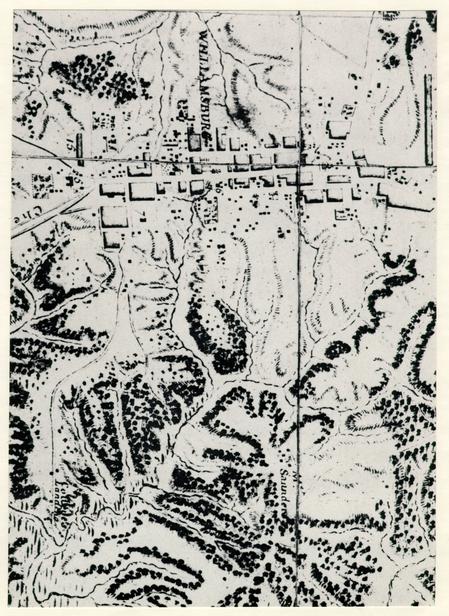 Figure 1 - Detail of Col. Desandrouin's Map of 1781 showing position of the Saunders plantation buildings in relation to the environs of Williamsburg.
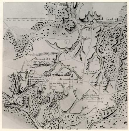 Figure 2 - The Capitaine Map of 1781 showing features on the Saunders plantation site as well as access roads absent from the Desandrouin Map.
49-W-260-B
Figure 2 - The Capitaine Map of 1781 showing features on the Saunders plantation site as well as access roads absent from the Desandrouin Map.
49-W-260-B
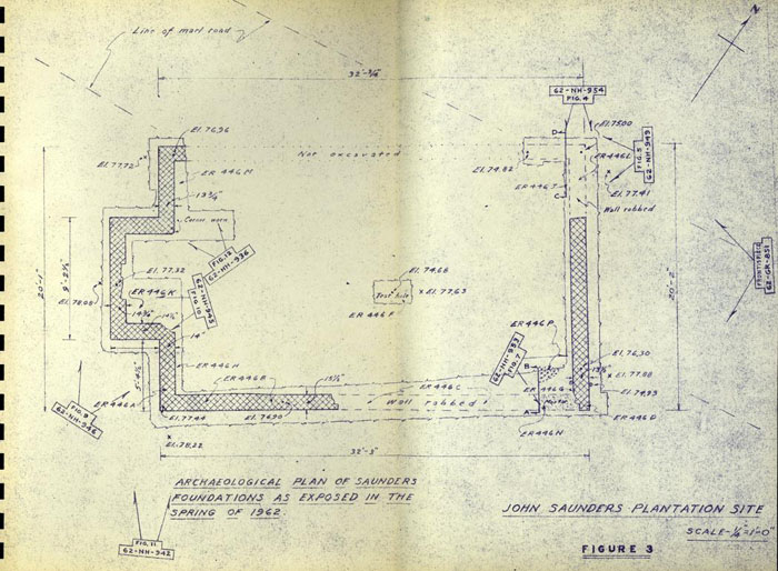 Figure 3
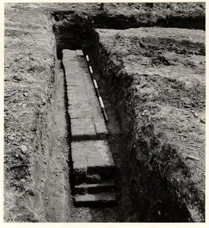 Figure 4 - East foundation with robbed section in foreground. Photo from the north. 62-NH-954
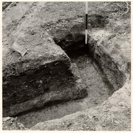 Figure 5 - Robbed north east corner of foundation with filling of yellow clay (arrowed) deposited before the brickwork was removed. Photo from east. 62-NH-949
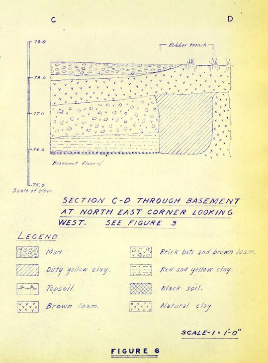 Figure 6
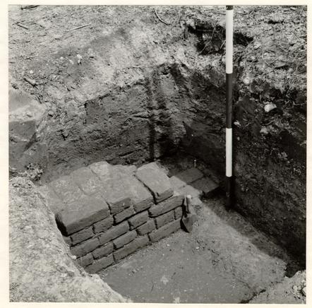 Figure 7
South east corner of foundation, trowel marking inner edge of robbed section of south wall; the brickwork standing at floor level. Photo from the north west. 62-NH-953
Figure 7
South east corner of foundation, trowel marking inner edge of robbed section of south wall; the brickwork standing at floor level. Photo from the north west. 62-NH-953
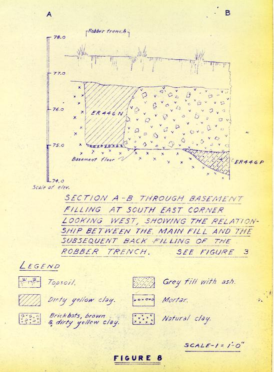 Figure 8
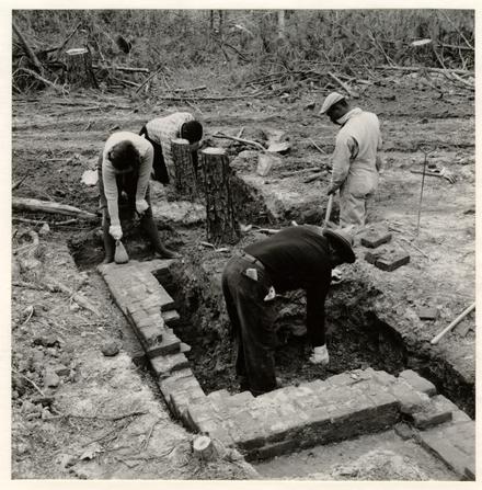 Figure 9 - The chimney foundation in course of excavation. Photo from the south west. 62-NH-946
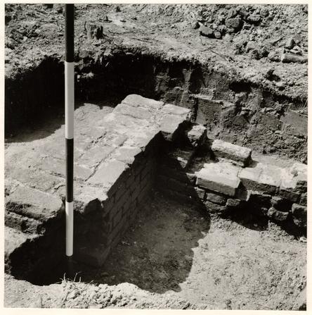 Figure 10 - Detail of interior south corner of chimney, with rubble fill partially removed and damaged back wall showing at right. Photo from the north east. 62-NH-945
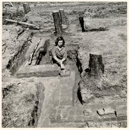 Figure 11 - The south east corner and chimney foundation in course of excavation. The north west corner can be seen to the right of the tree stumps in the background. Photo from the south. 62-NH-942
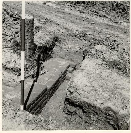 Figure 12
The north west corner, ranging pole standing at north east corner of chimney foundation. Photo from the south east. 60-NH-936
Figure 12
The north west corner, ranging pole standing at north east corner of chimney foundation. Photo from the south east. 60-NH-936
Figure 13
- 1.Body sherd from jog of Westerwald saltglazed stoneware, grey ware decorated with incised ornament and applied cobalt. German 2nd to 3rd quarter of 18th century. ER 446C
- 2.Mug rim, thin white saltglaze of good quality. English circa 1750. ER 446B
- 3.Saucer rim, white saltglaze. English circa 1740-1770. ER 446C
- 4.Rim sherd from pipkin, coarse brown saltglaze stoneware; body unevenly fired; lip slightly everted with cordon beneath. Virginia manufacture, possibly Yorktown. After circa 1725. ER 446C
- 5.Rim and wall fragments from slipware bowl, sgraffito decoration through white slip. Staffordshire, circa 1750-1770. ER 446D
- 6.Body sherd from pearl ware mug with marbled decoration. English, circa 1790-1810. ER 446K
- 7.Gilded brass button marked GILT on the back, very short brass shank and loop. Late 18th century. ER 446D
- 8.Fragments of wine glass stem, good quality, opaque white twist, 12 thread gauze and pair of corkscrews. English circa 1760-1780. ER 446B
(See E. Barrington Haynes, Glass through the Ages, London, 1959, p. 86, Fig. C)
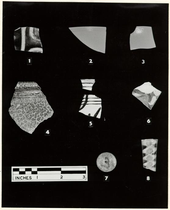 Figure 13 - Pottery and table glass
Figure 14
- 1.Handle fragment from large jug of Buckley ware, hard purple and yellow laminated body, thick black glaze; the rim of the jug apparently slightly flaring. North Wales, circa 1740-1780. ER 446H
- 2.Bowl, base fragment only, laminated pink and yellow body, purplish on the exterior, interior coarse yellow slip, streaks of manganese in the lead glaze. Staffordshire or North Wales, probably second half of 18th century. ER 446E
- 3.Wine bottle neck, deep olive green glass, circa 1750-1770 ER 455
- 4.Wine bottle neck, olive green glass, circa 1740-1780. ER 446N
- 5.Fragments of half round file, iron. ER 446C
- 6.Harness buckle, frame almost square, tang with ridge below the eye, iron. ER 455 (See I. Noel Hume, Excavations at Tutter's Neck, Fig. 16, No. 20, for example from context of circa 1730-1740.)
- 7.Rim fragment from large iron pot with mouth diameter of approximately 13 ½". ER 446M
- 8.Iron spike, hand wrought, flat-headed and round-sectioned to within 1 ¼" of the point, the latter square-sectioned; 3 ¼" in total length. ER 446B
- 9.Square-sectioned iron rod, tapering to a point at both ends; of uncertain purpose. ER 446B
- 10.Linch pin, shaft round-sectioned, eye flattened; iron. ER 446B
- 11.Round-sectioned iron rod with flattened loop at one end, the other end possibly broken; of uncertain purpose. Unstratified.
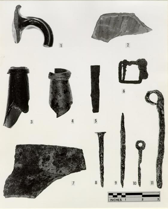 Figure 14 - Pottery, bottle glass and metal objects
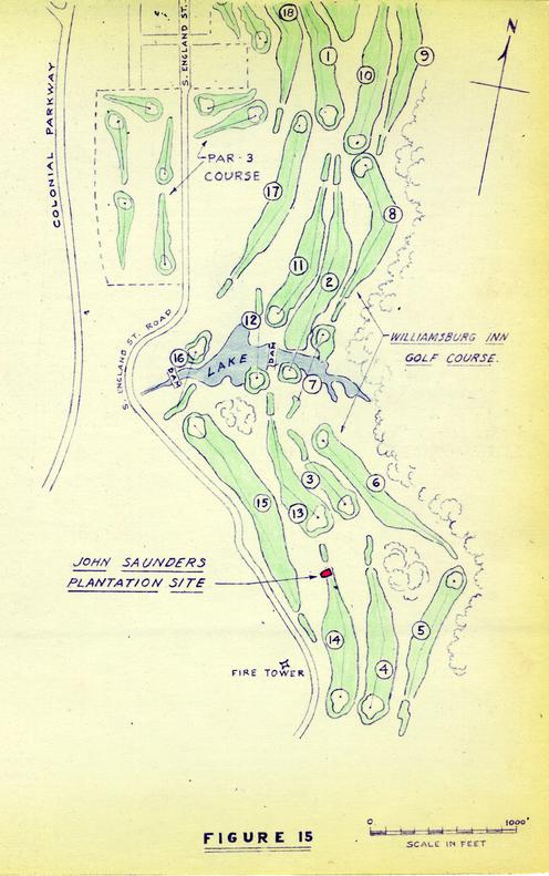 Figure 15 - Map
To: Mr. E. M. Frank
From: I. Noël Hume
Re: Attached copy of Saunders report
I am herewith sending you the finished report on the John Saunders Plantation Site for your perusal. I hope that it meets with your approval.
I. N. H.