Waters Storehouse Archaeological Report, Block 18 Building 3A Lot 49Originally entitled: "The Teterel North Outbuilding Archaeological Report on 1959 Re-Excavation Colonial Lot 49 Block 18 - Building B"
Colonial Williamsburg Foundation Library
Research Report Series - 1389
Colonial Williamsburg Foundation
Library
Williamsburg, Virginia
1990
ARCHAEOLOGICAL REPORT ON 1959 RE-EXCAVATION Colonial Lot 49
Block 18 - Building B
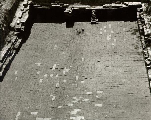 Fig.
1. The brick floor of period II as exposed in 1959. Note piers or cheeks of
period II chimney in background. Photo from the east.
Fig.
1. The brick floor of period II as exposed in 1959. Note piers or cheeks of
period II chimney in background. Photo from the east.
59-J.C.-946-9
| Table of illustrations | P. 1 |
| Introduction | P. 2 |
| Construction | P. 2 |
| Chimney | P. 3 |
| Bulkhead | P. 4 |
| Floors | P. 5 |
| Drain | P. 6 |
| Dating Evidence | P. 7 |
| Conclusions | P. 9 |
The draft of this report was submitted to Mr. O. M. Bullock, Supervisor of Architectural Research, in August 1959. The Ms. was approved and returned in September of the same year.
1| Fig. 1 Brick floor of Period II as exposed in 1959. | Frontispiece |
| Fig. 2 Bulkhead entrance of Period II with marl floor of Period I exposed in foreground. | Following P. 4. |
| Fig. 3 Cutting through brick floor against east wall to reveal marl floor and drainage gully of Period I. | Following P. 5. |
| Fig. 4 Cutting against pier or chimney cheek of Period II, exposing floor of Period I. | Following P. 5. |
| Fig. 5. Brick drain of Period I exposed outside west wall. | Following P. 6. |
| Fig. 6 Remains of burnt wooden bed head (?) found in filling of cellar. | Following P. 7. |
| PLAN Plan of area of 1959 excavations with relevant cross-sections. | Following P. 9. |
APPENDIX TO THE ARCHAEOLOGICAL REPORT OF 1932 ON COLONIAL LOT No. 49
Block 18, Building B
In the spring of 1959 the foundation to the rear of the reconstructed Teterel Shop was re-excavated in the hope of gleaning additional information relating both to its purpose and date.1 As a result of this operation it was deduced that the structure may have served as a storehouse rather than a kitchen, that it was constructed during the first quarter of the nineteenth century and rebuilt, possibly following a fire, in the middle of that century and finally destroyed at some date prior to c. 1895.
Evidence supporting the above deductions is laid out in the following report.
Construction
The brick-walled basement foundation lying on an east-west axis to the rear of the Teterel Shop possessed internal measurements of 27'-10" E/W, 16'-10½" N/S at the east end and expanding to 17'-10" at the west. The walls laid in haphazard bond had an average thickness of 1'-1", and specimen bricks from various parts of the structure exhibited the following 3 measurements:
| 8 x 3¾ x 2 5/8" | West wall. | Period One. |
| 8¾ x 4¼ x 2½" | East wall. | Period One. |
| 8½ x 4 x 2½" | Bulkhead. | Period One. |
| 8¾ x 4 1/8 x 2½" | Bulkhead. | Period One. |
| 8¾x 4¼ x 2¼" | Bulkhead. | Period Two. |
| 8¾ x 4¼ x 2 7/8" | Bulkhead. | Period Two. |
| 8¾ x 4 1/8 x 2¼" | Interior chimney (?) footing. | Period Two. |
The mortar used in the brickwork of the first period contained oyster shell, although the high proportion of sand indicated that the mixture was not in the best traditions of colonial mortar. The construction of the second bulkhead and the chimney cheeks (?) at the west end of the basement made use of lime mortar.
It is notable that the basement was built into ground rising to the east away from the Printing Office valley with the result that the brick wall at the east extended deeper below the contemporary grade than did the west. The east foundation (see plan) extended a full five courses below the brick floor of Period II, while that at the west descends only one and a half courses below the same floor.
Chimney
No evidence of a chimney associated with Period One came to light during either the excavations of 1932 or 1959, although exploratory cuttings were extended along the exteriors of both the east and west walls. However, the whole of the brick floor (Period Two) was not taken up and 4 consequently it cannot be stated positively that no interior chimney existed. (Fig. 1) Nevertheless, the top floor was removed in front of the central section of the east wall (Fig. 3) without revealing any evidence of a chimney. The brick floor was also taken up in the S.W. corner with similar negative results. (Fig. 4) It should be noted, however, that these incisions through the floors were not aimed at recovering traces of a chimney, but to determine the dating sequence of the floors. In view of the fact that no evidence of a chimney could be detected in the brickwork of the walls, it was assumed that none existed. But it could well be argued that any interior fireplace set in a corner or in the center of one of the walls (as was that of Period Two) could have abutted against it and have been removed without leaving any visible scars. While this fact was appreciated, the late date of the building influenced the Department of Architecture in abandoning the excavations before all the top floor had been taken up.
The so-called chimney of Period Two (Fig. 4) was constructed over and resting on the marl floor of Period I, and had a total width of only 5'-0" with cheeks a brick and a half in thickness. Such a fireplace would be much too small for use in a kitchen and thus seems to preclude the building from having been constructed for that purpose.
Bulkhead
The bulkhead at the eastern end of the building's south
wall had been excavated and totally exposed (though not dismantled) during the
1932 excavations, at which time it was noted that it represented two periods of
construction (Fig 2). It appears that the bulkhead of Period
One had an original width of approximately 5'-0", used the footing of the
south E/W wall as part of the bottom step, and possessed a course of headers
extending south
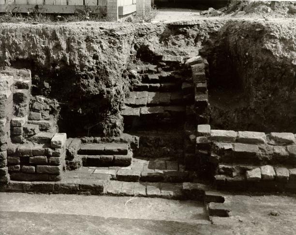 Fig. 2 Bulkhead steps of Period II partially exposed. Cheek of Period I bulkhead
to left and cutting through brick floor to marl of Period I in foreground. Photo
from the north.
Fig. 2 Bulkhead steps of Period II partially exposed. Cheek of Period I bulkhead
to left and cutting through brick floor to marl of Period I in foreground. Photo
from the north.
59-J.C.-736-4.
5
from it, backed by a series of bats creating in all a 1'-0" span to the
south to seal over the loosely filled builder's trench that ran all round the
exterior of the building. The filling thus stabilized, the steps of the bulkhead
were laid over it and cutting back into the undisturbed clay bank.
At sometime about the middle of the nineteenth century the bulkhead was destroyed, the west cheek section provided by the south wall also being damaged. Subsequently (at the same time that the brick floor was laid) the damaged face was repaired and the undamaged east face obscured by a two brick buttress or cheek which served to narrow the Period Two bulkhead considerably.
It was suggested by Mr. John Henderson that the buttress and steps of the Period Two bulkhead be removed in the hope of exposing sockets for wooden nosings let into the Period One east face. However, for the reasons stated previously, the Department of Architecture decided against continued investigation in this direction.
Floors
The brick floor of Period Two was evenly and carefully
laid (without mortar) running in an E/W direction, but turning and running N/S
in a somewhat arbitrary manner in the N.E. corner. (Fig. 1).
It had been hoped that directional changes in the laying of the floor might have
indicated some partitioning of the floor area. However, the change of direction
was too irregular for any such conclusions to be reached. It was noticed that
the brick floor possessed an unintentional concavity running down the center of
the building from east to west. It was later found that at that point the bricks
overlay a loosely filled drainage gully running on this
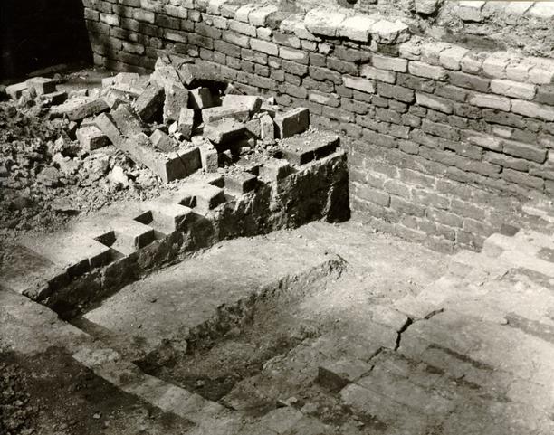 Fig.
3 Cutting through brick floor of Period II against east wall, exposing
Period I marl floor and central drainage gully. Photo from the west.
Fig.
3 Cutting through brick floor of Period II against east wall, exposing
Period I marl floor and central drainage gully. Photo from the west.
59-J.C.-736-3.
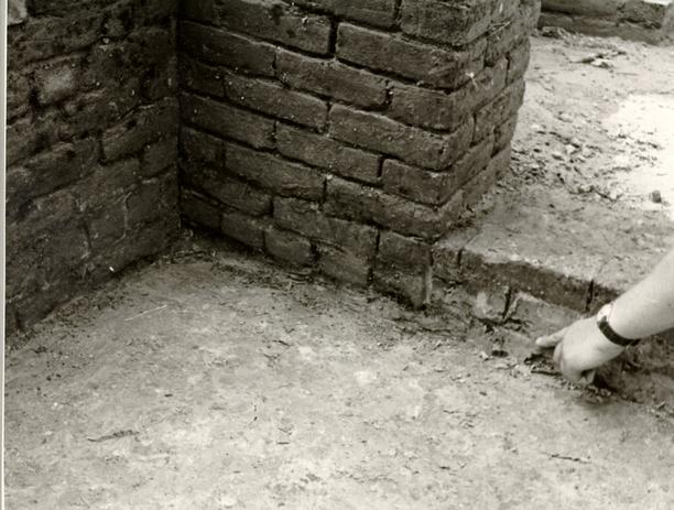 Fig.
4 Cutting against pier or chimney cheek of Period II exposing marl floor of
Period I. The finger indicates the top of a thin layer of fill containing brick
fragments, potsherds and coal chips. It will be noticed that the brick cheek
rests on this stratum. Photo from the southeast.
Fig.
4 Cutting against pier or chimney cheek of Period II exposing marl floor of
Period I. The finger indicates the top of a thin layer of fill containing brick
fragments, potsherds and coal chips. It will be noticed that the brick cheek
rests on this stratum. Photo from the southeast.
59-J.C.-736-1.
6
line through the marl floor of Period One. (Fig. 3).
The brick floor rested on a layer of yellow clay that varied in thickness from 2" at the west to 6" at the extreme east. Beneath this was a layer of marl varying in thickness from 1" to 1½" which in turn rested in a stratum of dirty clay 1½" in thickness at the west and 4½" towards the east, and increasing to 7½" in a shallow concavity in the natural clay beneath in which the east foundation stood. In this area the dirty clay was mixed with bats in a deliberate effort to make solid the backfilled concavity beneath the marl floor.
The Drain
The previously mentioned drainage gully divided the marl floor down the center and was cut into natural clay beneath. On reaching the west wall the water passed through a gap in the brickwork (not exposed) and entered a shallow brick drain with walls one brick thick and capped by a single row of stretchers. (Fig. 5). This was exposed for a distance of 8'-0" in a westerly direction from the west wall, the drain exhibiting the following drop in the course of that distance:
| at W. Wall | at 8'-0" |
|---|---|
| Top of drain: elev. 75.69 | elev. 75.42 |
| Clay bottom: " 74.67 | " 74.38 |
The drain was found to be filled to the roof with mud. But no artifacts were recovered from it. However, the fact that the gully was open during the period in which the marl provided the floor of the building, but was sealed over when the brick floor was laid, there is no doubt that the gully and brick drain were in service only during Period One.
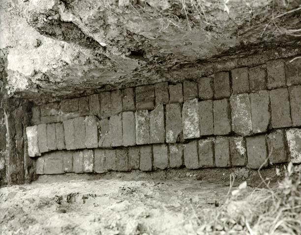 Fig.
5 Brick drain of Period I running west from the building towards the
Printing Office valley. Photo from the west.
Fig.
5 Brick drain of Period I running west from the building towards the
Printing Office valley. Photo from the west.
59-J.C.-764
When the brick floor of Period Two was laid the gully inside the building was deliberately filled with dirt and pieces of wood, one of the latter having measurements of 2'-3½" x 7" x 5½". It was the decaying of this and other pieces of wood that caused the brick floor to settle along the line of the gully. The dirt fill packed around the pieces of wood contained wood ash, nails and burnt window glass. Such evidence might be used to suggest that the building of Period One was damaged by fire. However, there was not enough such debris forthcoming for any worth-while conclusion to be reached. In this connection it may be noted that what at first appeared to be evidence of fire overlying and pressed into the marl floor was found to be caused by numerous small pieces of coal and coal dust that were found scattered wherever the marl was exposed in the recent excavations. The coal was found in the greatest concentration in the S. W. corner. It may be suggested that the basement was used for the storage of coal at some time during Period One.
Dating Evidence
Evidence relating to the construction date of the building came primarily from the builder's trench running N/S outside the east wall. The trench, 1'-4" at its greatest width, cut through strata containing ceramic fragments ranging from good quality saltglaze of c.1740-60 to Staffordshire hand-painted white earthenwares of the first quarter of the nineteenth century. It was apparent, therefore, that the trench could not have been dug before the latter date. The trench itself yielded a fragment of a cylindrical wine bottle that probably dates from the early nineteenth century.
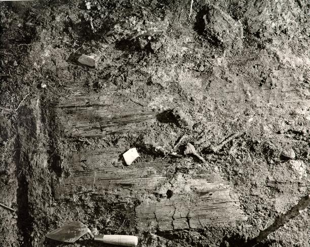 Fig.
6 Remains of burnt wooden object, perhaps part of a wooden box or bed head,
found in charred debris thrown into the basement after the destruction of the
building. Photo from the south.
Fig.
6 Remains of burnt wooden object, perhaps part of a wooden box or bed head,
found in charred debris thrown into the basement after the destruction of the
building. Photo from the south.
59-D.W.-690-4.
Less informative was a fragment of burnt stoneware (storage jar rim sherd) found impressed into the marl floor at the east end of the building, for this could readily date anywhere between the mid-eighteenth and mid-nineteenth centuries. More helpful was a small fragment of a transfer-printed Staffordshire pitcher of about 1820 that was found pressed (possibly mixed) into the marl in the S. W. corner of the building. It was therefore shown that the brick floor could not have been laid before that date.
The brick floor of Period Two was covered by 6"-1'-3" of silted clay, apparently representing mud that had been washed into the basement after the building had been dismantled above ground. No artifacts were found in this layer. Above it was a stratum 6"-1'6" in thickness comprised a quantity of brunt wood (Fig. 6), burnt crockery, medicine bottles, etc., dating from the second half of the nineteenth century and probably representing debris from a nearby fire. The presence of the thick stratum of silt beneath the burnt layer clearly precluded the latter from any association with the destruction of Building B. It might, however, be suggested that the debris came from the fire of c. 1895 when the whole block burned. If this were so then it follows that Building B had ceased to exist by some undetermined date prior to that fire.
Mr. John Henderson has provided the following information concerning fires in the vicinity during the nineteenth century, evidence that may have had some bearing on termination of Building B's Period One and upon the filling of the basement at the end of Period Two.
9| c.1842 | Thomas Sands — main buildings |
| c.1842 | Robert Anderson — rear buildings |
| (These were on the Printing Office lots) | |
| 1850 | William Coleman's house |
| 1850 | Shields' House |
| (Lots 49 & 50) | |
| 1895 or 1896 | Whole block burned |
| 1922 | Braithwaite's store in middle of block burned |
Conclusions
Building B was constructed no earlier than the first quarter of the nineteenth century, and during the early years of its life the basement was used for storage of coal and presumably other unidentified commodities.
At sometime after c.1820 an undetermined event occasioned extensive alterations to the building including the addition of a possible chimney, the laying of a new brick floor, and the rebuilding and narrowing of the bulkhead entrance. It is suggested that these alterations may have occurred in the mid-nineteenth century.
It appears that the building ended its life during the second half of the nineteenth century and that the basement remained open, though partially silted, at the time of the fire of c.1895. No indication of the cause of the destruction of the building was revealed through archaeological investigation.
The site was back-filled in July 1929.
July 27, 1959
I. N. H.
Footnotes
"Foundation "B" apparently is very old and probably is colonial. Two trees, about two feet in diameter, were found growing in the center of it. The basement was not excavated, but holes were dug in the corners and a brick floor found, which probably extends over the whole of the basement. A Basement entrance was found at 4, which shows evidences of alteration at a later period. The bricks in the lowest courses are laid with oyster shell mortar in running bond with headers every fourth course. The upper courses of the foundation are evidently of a later period, for the bricks are laid in lime mortar and mixed bond. Foundation walls found at 5, apparently forming a chimney, were also added after the outside walls. The mortar is ordinary lime and sand mortar."