Peter Scott House (NB) Archaeological Report, Block 13-1 Building 30A Lot 354Originally entitled: "Report on Archaeological Excavations on the Peter Scott House Lot 354 Block 13"
Colonial Williamsburg Foundation Library Research Report Series - 1273
Colonial Williamsburg Foundation Library
Williamsburg, Virginia
1990
Report on Archaeological Excavations on the
PETER SCOTT SITELot 354 Block 13
TABLE OF CONTENTS
| Table of Illustrations | 3 |
| Table of figures and plans | 5 |
| Explanation | 6 |
| Summary of results | 7 |
| The historical evidence | 12 |
| The Peter Scott cellar - archaeological data | 18 |
| Summary of cellar chronology | 24 |
| Cellar construction data | 25 |
| Lot 354. W. Property boundary - archaeological data | 27 |
| Post holes not associated with N/S fence line | 35 |
| Colonial structural remains to rear of Scott house - archaeological data | 38 |
| Early nineteenth century brick foundation to rear of Scott house, building "B" archaeological data | 45 |
| Structure pre-dating building "B" archaeological data | 46 |
| Comparative brick sizes from structures B, D, & E | 47 |
| Foundation complex on eastern half of Lot 354 - archaeological data | 47 |
| Trashpits on the Peter Scott site | 51 |
| Descriptions of the illustrated artifacts | 54 |
| Plate X | 54 |
| Plate XI | 55 |
| Plate XII | 58 |
| Plate XIII | 59 |
| Plate XIV | 61 |
| Plate XV | 63 |
| Plate XVI | 65 |
| Plate XVII | 65 |
| 2 | |
| Plate XVIII | 66 |
| Plate XIX | 67 |
| Plate XX | 69 |
| Plate XXI | 70 |
| Plate XXII | 71 |
| Index of Excavation Register numbers and Table of Archaeological Dating for Stratified Groups | 73 |
TABLE OF ILLUSTRATIONS
| Frontispiece: | Grid excavation in progress to the east of Lot 354 |
| Plate I | Scott cellar excavation from the southeast. Following P.18 |
| II | Scott cellar excavation after completion, from N. E. |
| III | Detail of cellar brickwork, interior of west wall |
| IV | Furnace and chimney complex revealed in 1955 |
| V | Robbed remains of N. W. corner of building "B" |
| VI | South wall of building "B" with earlier mortar spread in foreground |
| VII | Galt Cottage porch overlying earlier, brick foundation |
| VIII | 19th century foundation with builder's trench visible to left of it |
| IX | Brick foundation under Galt Cottage porch with builder's trench to right of it |
| X | Creamware and Colono-Indian pottery |
| XI | Post-colonial white earthenwares, scratch blue and saltglazed wares |
| XII | Brown and grey stonewares of the Colonial period |
| XIII | Relics from the floor of the Scott cellar |
| XIV | Tobacco pipes, ceramics and glass from various deposits |
| XV | 18th century beverage bottle fragments |
| XVI | Early 18th century bottles from the floor of the Scott cellar |
| XVII | Virginia halfpenny of 1773 from the Scott cellar |
| XVIII | Small finds from the vicinity of the Scott cellar |
| 4 | |
| XIX | Iron items from various deposits |
| XX | Iron items from various deposits |
| XXI | Iron items from various deposits |
| XXII | Iron items from Lot 354, recovered in 1955 |
TABLE OF FIGURES AND PLANS
| 1. N/S section between chimney and cellar of Scott house Following | p. 20 |
| 2. E/W section through filling of Scott cellar" | 20 |
| 3. Plan of 1958 re-excavation north of Galt Cottage site " | 47 |
| 4.Section through strata south of Chamber of Commerce site " | 51 |
| 5.Plan of 1958 excavations on western section of Lot 354 " | 75 |
EXPLANATION
The following report on the Peter Scott site has a twofold purpose, first to bring together all available archaeological evidence concerning the structural remains and their respective dates, and secondly to describe all significant, archaeologically dated artifacts.
It is intended that the dated artifacts illustrated on the following pages will be used to aid in the identification and dating of objects subsequently excavated elsewhere. The Excavation Register (E.R.) numbers overlying each item refer to the context in which the object was found. The dates of these contexts can be determined without reading through the text by referring to the index table on pages 53-54. Thus, for example, a binge illustrated as Pl. XIX, No. 1, has the E.R. number 72F. The index table gives the date of the context as 1776. This is followed by the numbers of pages on which the dating evidence is discussed. In this way the reader may either accept the given date or explore the reasoning further., according to his requirements.
It should be remembered that the dates given in the index table refer to the deposition or most recent disturbance of the soil in which the objects were found. It does not, necessarily provide a date for the artifacts themselves. That data, if available, is only to be found with the description of each item in the text.
December 12, 1958
I.N.H.
Report on Archaeological Excavations on the
PETER SCOTT SITE
Conducted by the Archaeological Section of the Department of Architecture
June-August, 1958
The above excavation represents a continuation of the work carried out under the direction of Mr. J. M. Knight in 1955 and should therefore be treated as a supplement to his findings.
SUMMARY OF RESULTS
Work commenced to the rear of the existing Chamber of Commerce lot in the vicinity of the previously excavated chimney and furnace foundations in the hope that further light might be shed upon the date and purpose of these features. Some data was, in fact, forthcoming although it did not add to the available information concerning the history of the Lot during Peter Scott's long tenancy. It was found that the chimney was probably of Colonial date on the evidence of shell mortar used in its construction. The so-called furnace contained similar mortar as well as a later repair making use of limestone mortar. Subsequently the foundations of an early 19th century building were located N. W. of the furnace and south of the Chamber of Commerce building, and an examination of the mortar showed it to be similar to that used in the repair of the furnace. The approximate date of construction and destruction of the building appear to be c.1800-1815 and 8 c.1840-50, and it is reasonable to assume that the originally Colonial furnace was reused between these dates.
After the Chamber of Commerce building had been removed from the front of the lot, excavations were continued (following Mr. Knight's work of 1955) in the western end of the supposed Peter Scott cellar and around the previously located chimney. It was found that a number of pits and post holes bad been dug into and around the Colonial chimney foundations as well as into the west wall of the cellar. These holes could not be associated with the mid-nineteenth century foundations which supported part of the Chamber of Commerce building, and as two of the holes were sealed by that foundation there can be no doubting that they are of an earlier date. It may be suggested, though not proved, that the holes were associated with a temporary or pier-supported structure which stood on the site contemporaneously with building "B", whose foundation was exposed to the rear of the Chamber of Commerce.
The nineteenth century building, "C", which stood on the above site from c.1840 was somewhat smaller than the restored building, having a walled foundation extending southward twenty-one feet and being fourteen feet, six inches in internal width. The walls averaged eight inches in thickness and made use of a sandy yellow mortar. Part of a brick hearth survived within the building as well as the roughly laid foundation of the chimney without. A southern extension of this building was supported at its southeast and southwest corners with right angled piers whose mortar was similar to that of the northern foundations. The base 9 of a small chimney was situated approximately midway between the two piers and its mortar was the same as that used for the other foundations. It was assumed that this small square chimney had no hearth but was fed by a stove. The final Chamber of Commerce building extended approximately four feet, four inches beyond the southern extremity of the nineteenth century structure as it existed when the square chimney was in use.
As already mentioned, the western section of the Colonial cellar was excavated down to natural, save for a square balk in the southwest corner and for two balks lying beneath the eastern Chamber c Commerce foundation. These areas were deliberately left so that they will remain to be studied by future archaeologists should it be decided that the Peter Scott Site will not yet be developed. It was found that, following the fire of January 21, 1776, the cellar remained open, though littered with burnt timbers and bricks until the first decade of the nineteenth century, at which time it was deliberately filled with soil and domestic trash. It could be suggested that this filling roughly coincided with the digging of the post holes in the vicinity of the Colonial chimney. Excellent dating evidence for the destruction of the colonial building was provided by a Virginia halfpenny of 1773. The coin was in mint condition and as it is known that the pieces were not issued in the Colony until 1775, it is reasonable to suppose that its new state indicates that it had been in circulation for a very short space of time. (See Pl. XVII). A quantity of melted glass was found in the northeast corner of the cellar excavation and as all the panes appeared to be of small size and in view of the fact that panes of differing quality and thickness had fused 10 together, it can be suggested that these were relics of Peter Scott's cabinet-making operations and bad been left in the cellar after his death. Other finds included band-wrougbt nails and binges (Pl. XVII and XIX); one of the latter possibly from the cellar's bulkhead doors.
Evidence for the construction date of the colonial building was provided by two fragmentary glass beverage bottles found in a sandy clay-filled depression in the cellar floor against the west wall. It appeared that the pieces of glass bad been mixed with the dirt and bad been swept into the depression and allowed to remain there to level the clay floor of the cellar which dipped four inches in four feet towards the west wall. The two bottles were of the earliest form normally encountered in Williamsburg and dated c-1710. As the historical evidence shows that John Custis must have erected a building on the lot by 1717, it is fair to accept the bottles as evidence that this was the structure in question. (See Pl. XVI).
The cellar walls were stoutly and trimly constructed on the inner faces, but were somewhat uneven on the outside and of varying thickness. Of particular interest was the fact that the mortar between the bricks was neatly scored on the inside to within three courses of the bottom - a characteristic which is normally associated with exterior faces.
The only remaining discovery of consequence resulting from the 1958 excavations was the location of a much used fenceline running north south against the west face of the colonial chimney and inside the line of the western nineteenth century foundations. 11 The exterior of the western wall of the early nineteenth century building ("B") was situated on the same line, but gave way to further post holes to the south of it. So long established did this property line appear to be that there seemed little likelihood that any Peter Scott buildings would have extended west of it. For this reason plans to extend the excavations onto the adjacent lot were abandoned.
It will be seen from the preceding summary that very little new data resulted from the 1958 excavations beyond the discovery that the furnace to the rear of the property was almost certainly associated with Peter Scott's tenancy of Colonial Lot 354. No traces of an outbuilding were discovered although a thin spread of shell mortar, apparently in situ, was discovered running in a north south line beside and under the southeast corner of building "B". (See P. 30). A number of bricks with shell mortar attached were found in a trash pit (E.R.109) south of the same building as well as scattered through early nineteenth century layers in its vicinity. It could, however, be suggested that they had been associated with the previously excavated chimney (D on plan).
In short, the sequence of events as indicated by the archaeological evidence, would seem to have been as follows:
- 1.c-1716 John Custis constructs building "A".
- 2.Chimney "D" and furnace "E" are built.
- 3.1775-76 Peter Scott's effects moved out of building "A". Troops billited these.
- 4.1776 Building "A" burns.
- 12
- 5.c.1800-35 Cellar of building "A" filled in; posts driven west of it; building "B" constructed, furniture "E" repaired, the two apparently being associated with metal-working.
- 6.c.1840-50 Building "B" destroyed, possibly by fire.
- 7.c.1840 Furnace "E" no longer in use.
- 8.c.1840 Building "C" constructed.
It must be realized that the above dates are simply opinions based upon the positive archaeological evidence. Negative evidence may be suspected but it cannot be used in the present instances. It is possible, for example, that the discovery of pottery fragments in a post hole dating up to c.1840 may give a wholly incorrect impression simply because there were no other later fragments present to provide the true date of, say, 1865. The 1840 evidence does provide, however, a date post quem which cannot easily be disputed. Consequently, in instances where there is no conflicting data and where the archaeological dating seems reasonable (in this writer's opinion) the post quem dating has been accepted as being accurate.
THE HISTORICAL EVIDENCE
The following data is derived from Miss M. A. Stephenson's research report on Colonial Lot Block 13, dated July 1952.
In 1714, lots 353, 354 and 355 were granted to John Custis by the trustees of Williamsburg and, in compliance with the Act of 1705, he was required to construct a house on each of the lots within twenty-four months of acquisition. It is evident, therefore, that Custis must have built on Lot 354 by 1717.
13It is known that Custis erected a "tenement" on Lot 355, east of 354. It is further established that Peter Scott lived in a house on one or other of the lots, there being a reference to "Mr. Custis's Tenement, where Scott lived opposite to the Church". The word lived is there of some importance, it having been considered unlikely that Scott bad his home in the same building as his shop. (See p. 6).
In an advertisement in the Virginia Gazette of September 12, 1755, there appears the following words:
"Peter Scott, advertises 2 lots on the Back Street,, near Col. Custis's on which there is a good Dwelling House Containing Six Rooms and Closets .... likewise will be sold, at the Subscriber's Shop near the Church, sundry Pieces of Cabinet Work ...."
This suggests two things, one that Scott possessed property on Francis Street, probably behind the Custis Maupin House and or directly to the rear of his own shop site, and two, that Scott's shop was close to the Church. Evidence that Scott rented the Duke of Gloucester Street property from Custis's estate is provided by entries among the Custis Ms. Papers owned by the Virginia Historical Society, photostats of which are in the Colonial Williamsburg Research Department. These entries range from 1757 to 1771.
Peter Scott died in the winter of 1775. Subsequently the house was occupied by revolutionary soldiery. On the twenty-first of January, the house was destroyed by fire and accounts of the disaster appeared in the Virginia Gazette of the twenty-sixth of January, 1775, saying:
"Mr. Peter Scott's old house in this City, which he had rented and lived in for 43 years, was burnt down last Sunday Night, by accident."14 and in a letter from Edmund Randolph to George Washington of the same date, reading as follows:
"About 5 Days since, Mr. Custis's Tenement, where Scott lived, opposite to the Church, was burnt to the ground, by the Negligence of some of the Soldiers, who had been quartered there. The Wind, being due South, the out-house escaped Flames. The Difficulty of saving the Church became thereby very great. The Country are surely answerable for this Damage, as it accrued in their Service."(Emmet Collection #1135, New York Public Library, copy in Research Department).
It is, perhaps, significant that no mention is made of the building having been anything but Scott's residence. It could, therefore, be suggested that the Colonial foundations exposed in 1955 and 1958 are those of Scott's house and not of his shop. The two references to the fire both indicate that only one building was destroyed which could be construed to mean either that there was but one main structure on the lot or that the other (the shop?) was not damaged. However, there was a reference to an "out-house", no trace of which has been found. The Frenebman's map adds further confusion by showing no buildings at all on the site in 1782. It may be wondered whether this indicates that no other buildings were situated thereon or whether they were merely of insufficient interest. The Frenchman's evidence does not support, therefore, the theory that the shop was a separate building standing on Duke of Gloucester Street to the east of the burnt structure. 1
15At some time after October 10, 1778, John Parke Custis Bold Lot 354 to John Greenhow who died in 1787 leaving the property to his son, Robert Greenhow. The College Map of 1791 (?) and the Bucktrout map of 1803 both show "Greenhow" on this property. By c.1820 Thomas Nelson of Yorktown held the lot and ten years later (1830) it passed to Benjamin Bucktrout and from him, in 1836, to William Edloe. In 1846 Edloe made sundry repairs and alterations to his property including the putting up of a stove possibly a record of the installation of the stove at the rear of the nineteenth century structure until recently occupied by the Chamber of Commerce.
The Williamsburg Land Tax of 1820 values the lot at $200, but at the death of Edloe in 1851, the property was worth $2000, suggesting that extensive additions and improvements bad been made during the preceding thirty years. It is reasonable to suppose that the construction of the Chamber of Commerce building would have been one such improvement - a suggestion which is supported by the archaeological evidence.
In 1851, following the death of Edloe, an attempt to sell the property failed, but in 1853 it passed into the bands of William G. Morrisett for the sum of $1800. Three years later be offered it for sale stating that it consisted of a "LOT, WITH DWELLING-HOUSE, STORE and sundry out Houses on the Main Street ....". It could be inferred that the reference to the store was to building "C".
No direct reference has been found to building "B" in any of the available papers and it must be assumed that if and 16 when it does appear, the structure is grouped with other outhouses. However, the archaeological evidence points to its destruction around or after c.1840-50. Two important questions are raised: 1) whether the building was still standing when Morrisett offered the property for sale in 1856, and 2) whether it was built during the period in which the property increased in value, i.e. c.1820-51. The archaeological evidence does not support such a theory, pointing to its having been built earlier in the nineteenth century.
In his "Recollections of Williamsburg", Mr. John S. Charles stated that there were two large buildings on the lot, one a two story building with one story addition to the west" and the other "a very large frame house, very old, with its roof projecting over in front supported by posts in the ground. The house extended nearly the entire width of the lot and was used as a kitchen and servants' quarters. It was destroyed by fire not many years ago." No trace of this large building was found during the 1958 excavations. However, one might speculate as to whether building "B" might have been associated with it early in its life. It is, perhaps, curious that there are no other identifiable references to this "very large" and "very old" house.
In summary the salient dates in the history of the site are as follows:
| 1714 | John Custis granted Lot 354. |
| 1733-1776 | Property rented by Peter Scott. |
| 1776 | Troops billeted and house burnt. |
| after 1778 | John Parke Custis sells Lot 354 |
| 17 | |
| c.1782 | John Greenhow acquires Lot 354. |
| 1787 | John Greenhow leaves property to his son, Robert. |
| before 1820 | Lot sold to Thomas Nelson. |
| 1830 | Benjamin Bucktrout owner. |
| 1836 | William Edloe owner. |
| 1853 | William G. Morrisett owner. |
Subsequently the lot was bought by Talbot Sweeney (1858) and in 1870 it passed to Nathaniel and Cicero Sweeney who in turn passed it to the Maupin family who retained it until the property was acquired by Williamsburg Restoration.
It will be evident from the foregoing that a modicum of confusion reigns, resulting in part from the loss of the court records for the James City County section of Williamsburg, and in part from an inability to determine to which structures on the lots the surviving references refer.
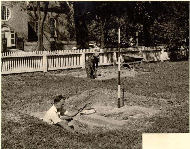 Grid Excavation in Progress to the East of Lot 354.
THE PETER SCOTT CELLAR - Archaeological data
Previous excavations directed by Mr. Knight (1955) had resulted in the clearance of the eastern part of the cellar and had included the driving of a trench beneath the Chamber of Commerce building through to the west wall. Shallow extensions from the latter trench in northerly and southerly directions had successfully located both the northwest and southwest interior corners of the cellar. Additional exploration beyond the west wall revealed the position of a partially robbed chimney. It will be appreciated, therefore, that the primary features of the Scott building bad been satisfactorily recorded prior to the removal of the Chamber of Commerce building and before the 1958 excavations were undertaken. All that could be expected from the additional work was the establishing of dating evidence for the construction and destruction of the Scott building and the provision of some clues as to the use of the area after 1776 and prior to the building of the nineteenth century shop subsequently the office of the Williamsburg Chamber of Commerce. Data significant to each of these problems was, in fact, forthcoming.
The area enclosed by the nineteenth century and later foundations (excluding the pier-supported rear or southern section) was divided into quarters, each being excavated as a separate entity and lettered as follows:
| S.W. | "A" | N.W. | "B" |
| N.E. | "C" | S.E. | "D" |
The N/S division between the western and eastern
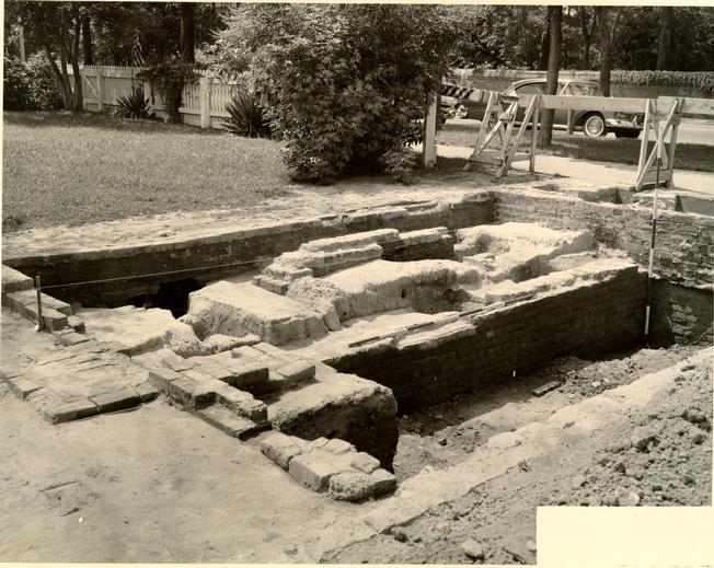 PLATE I. Scott Cellar Excavations from the South East.
19
quarters was provided by the line of the Scott cellar's west wall, the top of which had already been exposed by Mr. Knight's earlier trenching.
PLATE I. Scott Cellar Excavations from the South East.
19
quarters was provided by the line of the Scott cellar's west wall, the top of which had already been exposed by Mr. Knight's earlier trenching.
The first stage of the work within the cellar entailed the removal of the sand back-fill inserted into Mr. Knight's E/W trench after the close of the 1955 excavations. Once extracted two vertical sections were exposed extending from surviving top to bottom of the cellar's filling. However, it transpired that the north face of quarter or Q. "D" had been much disturbed by late nineteenth century intrusions. Consequently a measured section of the south face of Q. "C" alone was drawn. The section illustrated in Fig. 2 was subsequently based on the aforementioned drawing with the addition of stratification revealed after the floor of the cellar had been further exposed.
The cellar's filling (above the clay floor) was divided into four basic strata:
- 1.A thin layer of dirty brown soil flecked with burnt wood and containing artifacts dating into the second quarter of the nineteenth century. (E.R.71A), This probably represents a disturbance of an existing layer when the shop structure was erected over the colonial cellar. Average thickness of stratum: four inches to five inches.
- 2.Filling of brown clay dirt containing quantities of ceramic fragments of dates ranging from the mid-eighteenth into the first quarter of the nineteenth century. (E.R.71B and C.). The division between B and C in the Excavation Register was a purely 20 arbitrary one, filling 2 being divided at a depth of sixteen inches. This measure was taken in case a change of strata might have occurred which bad not been noticed by the unskilled laborers. No such division did exist in fact. A third division (E.R.71D) was made to classify all finds recovered from the bottom of stratum 2 as it overlay a fill of brick rubble (stratum 3). Here again no dating variation existed, the artifacts ranging from the eighteenth into the early nineteenth century. Thickness of stratum as a whole ranging from one foot, eleven inches at the west to two feet, five and one-half inches at the east.
- 3.Deposit of brick rubble extending from the walls and becoming thinner as it spread out into the cellar. (E.R.71E). The majority of the bricks bore traces of shell-lime mortar, but a few at the top of the stratum carried traces of limestone mortar. Others at the bottom, on the other band, bore extensive traces of burning and were liberally 21 intermingled with fragments of burnt wall-plaster. Artifacts from this layer were scarce, none of them dating any later than the last quarter of the eighteenth century. The principal find was an elaborately ornamented brass escutcheon from a furniture lock, presumably dating from the colonial period.
- 4.
Layer of burnt wood and plaster directly overlying the clay floor (E.R.71F). This stratum was thickest in the north west corner and ranged over-all from five inches to two inches in thickness. Finds from the layer included a quantity of burnt window glass (cabinet glass?) which was concentrated against the north wall in the northeast corner of the excavated area. (See Pl. XIII). One pane appears to be almost complete and measures only four and one-half inches by three and three-fourths inches. In some instances pieces of differing quality and thickness have fused together suggesting that the glass was stored in a pile at the time of the fire. Among other finds was a fragment of an English Delftware plate dating from the early eighteenth century (this pressed into the clay floor), part of a beverage bottle of the period c.1750-70, a quantity of iron nails, hinge fragments and wall plaster. The principal item, however, was a copper halfpenny of 1773, minted for use in the Virginia Colony. The piece was almost in mint condition and clearly-had not been in circulation for any appreciable length of time. In view of the fact that these coins were not issued in Virginia until March, 1775 2 and that Scott's 22 house burned in January, 1776, one may accept the newness and provenance of the coin as evidence that it was lost in a fire which occurred at such a date. (See Pl. XVII).
Numerous fragments of burnt wood were discovered in the destruction layer, but although it was apparent from the position of the nails that some of the pieces had been joined together when they fell, no recognizable objects or structural features could be identified.
- 5.The floor of the cellar was of clay interspersed with patched of sand and with a levelling filling of sandy clay against the west wall, four inches in depth at its thickest point. (E.R.84C). From the latter deposit came the remains of two glass beverage bottles (Pl. XVI), neither of which need date any later than c.1715, as well as a brass belt buckle (Pl. XVIII, No. 4). It is assumed that this fill was inserted to level off the cellar floor soon after the building was completed. Sandwiched between layers of clay (floor) in the northwest corner of the cellar was found a quantity o brick dust, It is probable that this was laid down while the cellar walls were in course of construction. A quantity of chicken bones (principally legs) were found pressed into the clay floor in the center of the excavated area (E.R.84A). A single fragment of an early eighteenth century beverage bottle was found in the floor close to the mid point in the east face of the excavated area (E.R.84B), while a number of iron nails and fragments of burnt wood lay directly on the floor in the same vicinity.
The southern section of the cellar filling, "Q. D", exhibited a very similar strata sequence as did "Q. C", although, as previously stated the north face and a considerable proportion of the upper levels had been disturbed by the digging of a rectangular trash pit at some date in the second half of the nineteenth century. This intrusive feature bears the designation E.R.72A, the finds from which included two axeheads, part of a pair of fire tongs, an iron hinge from the hood of a baby carriage, a brass purse frame and a brass plate from a harmonica. Other finds included broken medicine bottles, part of a molded wine glass and fragments of Ironstone china.
E.R.72B represents a layer of disturbed, ash-flecked soil abutting against and overlying the chimney flue in the south wall of the nineteenth century building. Finds from this stratum date up to the present century and are consequently of no interest or significance.
E.R.72C may be considered to be one with E.R.71B-D and dating up until c.1820, although the majority of the items belong to the closing years of the eighteenth century. Finds.include hand-painted "Staffordshire" wares, creamware, blue-edged wares., scratch blue, one sherd from a Spanish (?) storage jar, somewhat burnt, part of a brown stoneware pipkin handle and a handle from a similar vessel, white-slipped internally, and brown-glazed on the exterior over a red body, the ware comparable to an example from E.R.22-18H, the context dating to c-1770. Bottle fragments range in date from c.1710 to c.1800, while small finds include the top of a button of thin, plain brass (Pl. XVIII, No. 6), part of a belt buckle ornamented with molded scrolls and engraved
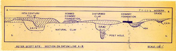 Peter Scott Site: Section on Datum Line A-B.
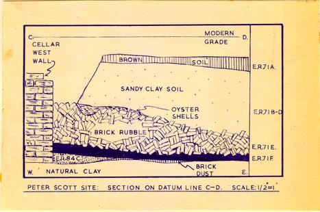 Peter Scott Site: Section on Datum Line C-D.
23
foliate decoration (Pl. XVIII, No. 5), and the much rusted jamb section of a T-shaped hinge (Pl. XIX, No.3). E.R.72D signifies a small area of stratum E.R.72C against the south cellar wall and immediately overlying the burnt destruction layer E.R.72 F and G. From 72D came a number of fragments of Colono-Indian pottery, the majority, if not all of them, from a flat-rimmed bowl of hitherto unrecorded form (Pl. X, No. 1, 11 and 14).
Peter Scott Site: Section on Datum Line C-D.
23
foliate decoration (Pl. XVIII, No. 5), and the much rusted jamb section of a T-shaped hinge (Pl. XIX, No.3). E.R.72D signifies a small area of stratum E.R.72C against the south cellar wall and immediately overlying the burnt destruction layer E.R.72 F and G. From 72D came a number of fragments of Colono-Indian pottery, the majority, if not all of them, from a flat-rimmed bowl of hitherto unrecorded form (Pl. X, No. 1, 11 and 14).
It was found that the tumble of brick rubble, which had been so prominent a feature of "Q. C", was much less pronounced at the southern end of the cellar, the bats being concentrated in the southwest corner but quickly running out towards the east. So few were the bricks at the southeast corner of the excavated area that they were simply mixed in with deposits C and D - or, more correctly C and D had poured around them until the bricks had virtually become part of these layers. This factor created some difficulties in excavation and to avoid confusion, the artifacts found amidst the bricks have been designated as E.R.72E-F. the first letter having been given to the brick rubble in the southwest corner (i.e. E.R.72E), from which no finds were retrieved. Layer 72E-F was in direct contact with the destruction layer and in some parts of the area merged into it. At this indistinct junction in the southeast corner of the excavation were found a number of fragments of heavily burnt brown stoneware, apparently from a substantial jug. Slightly to the north and against the east balk were located four perfectly preserved iron nails and a small iron blade of uncertain purpose (see Pl. XVIII, Nos. 10 and 12, and p. 47-48), and it is believed that these finds were, in fact, 24 associated with the destruction layer rather than with the filling above it.
The destruction layer proper was divided, for purposes of recording into two parts lettered F and G respectively. E.R.72F includes all finds from the southern half of "Q. D" and E.R.72G comprising those from the north. However, this division does not reveal any variation in date or style among the artifacts, there being fragments of the same items in both parts. Nevertheless, the letters have been retained in the register and are marked on the artifacts themselves. Finds of interest include an intact T-shaped binge of large size from E.R.72F (Pl. XIX, No. 1). and a group of baked mud-daubers' nests from E.R.72G (Pl. XII, No. 11). the latter with the imprint of the beams to which they bad been attached fired into their backs. A considerable number of chicken bones were located below E.R.72G pressed into the clay floor (see also E.R.84A), and it is conjectured that they may represent the remains of food eaten by the billeted soldiery shortly before the building was destroyed.
Summary of chronology
It is suggested, on the evidence of the beverage bottles found in the make-up of the cellar floor (E.R.84C) that the building was put up during the second decade of the eighteenth century. The absence of large identifiable artifacts indicates that the cellar had been virtually emptied after the death of Peter Scott (leaving, perhaps, a small heap of window glasses against the north wall), and that the soldiers billeted in the house had dropped their garbage bones there. On the evidence of the coin (E.R.71F) it is assumed that the fire occurred in 1775 25 or shortly thereafter. There is some indication that much of the debris was cleared away soon after the fire, but that the cellar lay open for thirty or forty years before finally being filled in.
CELLAR CONSTRUCTION DATA
As previously stated (p. 39), no new information regarding the construction of the cellar was revealed. Nevertheless, it may be useful to recapitulate to the extent of noting the basic facts recorded during the course of the work.
- 1.Cellar wall terminates at five feet, four and one-half inches below modern grade.
- 2.Top of destruction layer at an average of four feet, nine to ten inches below grade.
- 3.Shell mortar.
- 4.Mortar tooled between the bricks on the interior faces from surviving top to three courses from the bottom.
- 5.English bond. Specimen brick, nine inches by four and one-fourth inches by two and one-half inches.
- 6.Thickness of south wall: one foot, four inches. Thickness of west wall: one foot, one inch to eleven and one-half inches.
- 7.N/S width of cellar: seventeen feet, ten inches.
- 8.Depth of chimney from west wall to back: four feet, three and one-half inches. N/S length of chimney: nine feet,three inches. Wall thickness: one foot, one and one-half inches.
- 9.Cellar floor of rammed clay.
- 10.Hinge, possibly from bulkhead door, length: one foot, 26 eight inches. Length of longest surviving jamb nail: two and one-fourth inches. (Pl. No. p. ).
While clearing the cellar a two foot piece of burnt wood, five inches in width and one-half of an inch in thickness was found pressed against the west wall two feet, four inches from the southwest interior corner. As this board lay flush with the wall (Pl. III) and would have concealed the absence of tooling between the bottom three brick courses (see No. 4 above), it was deduced that the fragment indicated the presence of a skirting board running around the wall directly above the clay floor. However, subsequent excavation further north along the west wall showed that a hollow in the clay floor had been filled with sandy clay (E.R.84C, see p. 3) and as this deposit rose above the level of the bottom of the board and in view of the fact that no traces of wood were found sealed behind this sandy clay, it followed that any board along that section of the wall could not have been in existence after the deposit was laid down. Artifacts found in the aforesaid layer dated its deposition to the earliest period of the building's life, while the burning of the wood fragment indicated that the latter had been in existence up until the cellar's destruction. Consequently there can be no disputing that the section of wall hidden behind the filling E.R.84C had no skirting at the time of the fire. It must therefore be concluded that the identification of the board's purpose was incorrect and that it merely fell on edge against the wall during
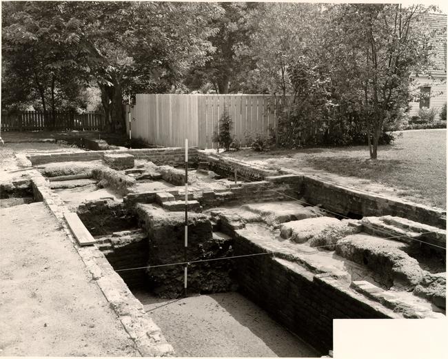 PLATE II. Scott Cellar Excavations after completion. From. N.E. 58-G.B.1019.
27
the fire and was subsequently pressed firmly against it by the bricks, timbers and earth which fell or were thrown into the cellar.
PLATE II. Scott Cellar Excavations after completion. From. N.E. 58-G.B.1019.
27
the fire and was subsequently pressed firmly against it by the bricks, timbers and earth which fell or were thrown into the cellar.
In conclusion it should be noted that an undisturbed specimen of the cellar's stratification was preserved in the southwest corner in the form of a buttress standing four feet, three inches in height above the burnt stratum, one foot, four inches in N/S thickness and four feet, one inch in E/W length. A N/S section was also preserved in the shape of two balks lying beneath the east N/S foundation of the Chamber of Commerce building and dividing the 1958 excavation from that of 1955. It should be remembered that the section was divided into two parts, having been cut by Mr. Knight's exploratory trench beneath the Chamber of Commerce, the building being still in use at the time of the earlier excavation.
LOT 354. W. PROPERTY BOUNDARY - Archaeological data
Excavations to the west of the Peter Scott cellar revealed a series of post holes running south from Duke of Gloucester Street directly to the west of the Scott chimney. The line stopped north of the west wall of building "B", the latter abutting against the property line and so projecting it southward. Post holes were again found south of building "B", but these could not be pursued as they lay beneath tree roots and other landscaped features. It was apparent that the property line had been much used and that more than one series of posts had been driven along it. Dating for each post was provided by the artifacts found in the filling. Unfortunately, however, it was not always possible to determine 28 whether the finds had been deposited in the hole as back-fill when the initial post hole was dug or whether they got there when the hole was finally filled after the post had been withdrawn. In the majority of instances the latter construction should be put upon the given dates. The series, reading for north to south, is as follows:
| Post hole | E.R. Number | Data |
|---|---|---|
| A | None | Rectangular hole partially beneath northwest corner of mid-nineteenth century foundation and thus ante-dating it. No other dating evidence. Hole protrudes into excavated area nine and one-half inches from north to south, one foot from east to west. Depth below modern grade: three feet. |
| B | 93 | Rectangular hole two feet, ten inches south of northwest corner of nineteenth century foundation and slightly beneath it on the western edge - thus antedating the aforesaid foundation. Finds comprise one edge fragment of window glass (probably eighteenth century) and one minute sherd of creamware or "Staffordshire" ware with creamware body dating from the last years of the eighteenth century. The hole extends i[nto] the excavated area one foot, one inch and has a N/S measurement of one foot, two inches. |
| 29 | ||
| Post hole | E.R. Numbers | Data |
| C | III | Oval hole lying partially beneath the nineteenth century foundation (west wall), six feet, eight inches from northwest corner. Artifacts from its fill include sherds of Westerwald chamberpot, hand-painted "Staffordshire" ware and one small fragment of transfer printed white eartbenware. Also present one poorly formed gun flint. Date range c.1760-1820. Hole extends towards Scott chimney nine and one-half inches and measures one foot, ten inches N/S. Depth below modern grade two feet, eight inches. |
| D | 112 | Square or rectangular hole lying partially beneath the west wall of the nineteenth century foundation eleven feet from the northwest corner. Artifacts include fragments of hand-painted "Staffordshire" ware, a handle sherd from a late scratch blue chamberpot, and a sherd of transfer-printed white earthenware and another with molded ornamentation. Date range c-1780-1830, or even later. Hole extends into area of excavation seven and one-half inches |
| 30 | ||
| Post hole | E.R. Number | Data |
| extends N/S one foot, seven inches. Depth below modern grade two feet, five inches. | ||
| E | 88 | Rectangular post hole as part of a larger and uneven hole of uncertain purpose. Post hole extending beneath the nineteenth century foundation; north edge of hole four feet, five inches north of north edge of post hole F (E.R.83). Finds include pieces of scrap iron (Pl. XX, Nos. 6-8), possibly from a forge in the vicinity, sherds of hand-painted "Staffordshire" ware (Pl. XI, No. 2) and a transfer-printed sherd bringing the top date no earlier than c.1820. Hole extends into area of excavation six and one-half inches, running N/S eleven inches. N.B. The remainder of the hole extending southward bears the number E.R.88A and contains artifacts similar to those from the post hole proper. |
| F | 83 | Rectangular post hole six inches north of southwest corner.of nineteenth century foundation and extending beneath it. Finds include a lump of shell mortar, sherds of hand-painted "Staffordshire" ware (Pl.X, No-5 red, overglaze, Chinese porcelain, and from the bottom of the hole, one sherd of English white saltglaze dating from the mid-eighteenth |
| 31 | ||
| Post hole | E.R. Number | Data |
| century. However, the top date must be set c.1820. Hole extending into excavated area eleven inches and the same distance. N/S. | ||
| G | 86 | Rectangular post hole three feet south of exterior southwest corner of nineteenth century foundation and partially beneath modern foundation of Chamber of Commerce building. Artifacts from this hole include part of a thin Delft handle of unusual form, a sherd of blue, feather-edged ware and another from a late scratch blue chamberpot. The top date for this assemblage need not be later than c.1790. The hole extends one foot east from the modern foundation and one foot, three inches N/S. |
| H | 91 | An irregular shaped hole two feet, four inches south of G and cut through by modern foundation. No definite post hole shape was identified, >but its position suggests that at least part of the hole had served this purpose. Finds include sherds of Delft, blue-edged white earthenware, English white saltglaze, creamware and a fragment of clay tobacco-pipe stem. Top date c-1780-1800. The hole measuring ten inches at greatest E/W width and two feet, seven inches N/S. |
| I | None | Small hole cut into by modern foundation, |
| 32 | ||
| Post hole | E.R. Number | Data |
| somewhat irregular shape and situated five inches south of H. The hole nine inches at its greatest E/W width and extending one foot, one and one-half inches N/S. No dating evidence. | ||
| J | 85 | Rectangular hole out through by modern foundation and situated two feet, six inches north from the southwest corner of the modern Chamber of Commerce footings. Finds comprise one sherd from a late scratch blue chamberpot and one sherd of Westerwald of uncertain form. This slim evidence indicates a top date no later than c-1770-1780. The hole extends ten inches E/W and one foot, one and one-half inches N/S. |
The presence of modern foundations and drainage cuttings coupled with an inability to excavate on the fence line directly to the rear of the Chamber of Commerce resulting from the close proximity of laundry yard fencing, caused a gap in the plotted post hole series between E.R.85 and E.R.97. It is,,assumed, however, that other holes would have been found if the blank stretch bad been undisturbed and available for excavation.
| Post hole | E.R. Number | Data |
|---|---|---|
| K | 97 | Rectangular hole situated against west face of excavated trench seven feet, seven inches south of Chamber of Commerce foundation. Finds comprised three fragments of creamware and one |
| 33 | ||
| Post hole | E.R. Number | Data |
| piece of bottle glass, none later than the decade c.1770-80. The hole extending one foot east from the west face of the trench at the south and with the northeast corner one foot, eight inches from the edge, N/S measurement one foot, three inches. Depth into natural clay seven inches. The existing fence line prevented the total clearance of this hole. | ||
| L | 96 | Enlarged hole, probably originally a post hole three and one-half inches south of hole "K". Finds include sherds of blue and green-edged wares (Pl. XI, No. 11), Westerwald, brown stoneware (Pl. XII, No. 3), and one small fragment of Colono-Indian pottery, group dating up to c.1800-1810. Hole extending east from west face of trench one foot, three inches at north, nine inches at south and running N.E./S.W. two feet. Depth into clay one foot, four inches. |
| M | None | Small rectangular hole three and one-fourth inches south of hole "L" from which no finds were recovered. Hole extending east from west face of trench at north six inches and at the south eight and one-fourth inches; N/S measurement: nine and one-half inches. Depth into clay: seven inches. |
| N | 95 | Rectangular hole in southwest corner of cutting one foot, one and one-half inches south of hole |
| 34 | ||
| Post hole | E.R. Number | Data |
| "M". No finds were recovered from the filling of the hole, but artifacts found in the overlying sealing stratum dated up to c.1810, suggesting that the post may have been withdrawn around that time. The hole extending east one foot, two inches and N/S one foot, four inches with a depth into natural clay of twelve and one-half inches to one foot, one inch. | ||
The fence line south of hole "N" was obscured,by the early nineteenth century building "B", indicating that the structure's west wall had been erected on the property line. The absence of any post holes dug through the filling of the robber trench indicates that the series of posts were not driven after the building had been destroyed. In all probability they were contemporary with it.
| Post hole | E.R. Number | Data |
|---|---|---|
| O | None | Rectangular hole five and one-half inches south of southwest corner of building "B". The hole cuts through a tumble of brick from the aforesaid foundation and therefore postdate it. Hole measuring one foot by eleven inches by seven inches and exposed at twenty-one inches below modern grade. |
The presence of a tree and landscaped bushes prevented the continuance of excavation in a southerly direction.
POST HOLES NOT ASSOCIATED WITH THE N/S FENCELINE Archaeological data
During the course of the 1958 excavations a number of post holes were found directly to the west of the Scott cellar foundation and in the vicinity of the building's chimney. Others were found around the furnace area to the rear of the site. But in neither case was there sufficient evidence to indicate the purpose of the posts. The data, such as it is, is as follows:
| Post hole | E.R. Number | Data |
|---|---|---|
| P | 82A | Rectangular hole cutting into the exterior of the Scott west cellar wall, the northeast corner of the hole seven feet, four inches of the Chamber of Commerce north wall and cutting into the colonial wall a distance of six and one-half inches. Fragments of oystershell mortar were recovered from the main filling of the hole (ER82A) while a fragment of an iron can (?) was found in the actual post mold.3 No dating is available beyond the obvious fact that the hole postdated the destruction of the colonial house. The hole measuring two feet E/W, and one foot, eight inches N/S, and terminating at three feet, two and one-half inches below the modern grade. The post itself had a diameter of seven inches and stood six and one-half inches out from the colonial wall. |
| 36 | ||
| Post hole | E.R. Number | Data |
| Q | 78 | Circular post mold four feet, two inches north of the south nineteenth century foundation under the Chamber of Commerce building and five inches west of N/S datum line. The post cutting through an existing filled trench the artifacts from which date no earlier than c. 1820. A single sherd found in the filled post mold must date the removal of the post no earlier than c.1830-50. |
| R | None | Circular post mold three feet north of south nineteenth century foundation under the Chamber of Commerce building and two inches west of the exterior of the Scott cellar. No dating evidence. Diameter of hole: eight and one-half inches. |
| S | 106 | Small, almost square post mold six feet, six and one-half inches south of nineteenth century chimney foundation under the Chamber of Commerce building and six feet, seven inches west of that building's modern eastern foundations. A small fragment of eighteenth century coarse pottery found in the filling of the hole has, unfortunately, been lost. The hole measuring six and one-fourth inches E/W, six inches N/S and extending five and one-half inches into natural clay. |
| T | None | Post hole against south foundation wall of building "B" and two feet, nine inches from |
| 37 | ||
| Post hole | E.R. Number | Data |
| the southwest corner to the center of the post. No artifacts were recovered. The fact that the hole extended slightly beneath the brick foundation suggested that it might predate building "B". Unfortunately, however, the evidence was not sufficiently clear to be conclusive. The hole extended twelve inches south from the foundation and ran one foot, four inches E/W. The post mold was found in the center of the E/W axis and abutting against the brick foundation. The post had a diameter of seven and one-half inches and had been driven into the ground one foot, six inches below the late eighteenth century grade. | ||
| U | None | Oval post hole eleven feet, three inches south of building "B" and with its eastern edge on a line nine inches west of the structure's southeast corner. No dating evidence. Hole measures one foot, three inches by eleven inches. |
| V | None | Round post mold four feet, six inches west of the south wall of chimney "D". No finds except two small fragments of metallic (iron?) slag from the bottom of the hole. Diameter of hole eight inches and terminating two feet, ten inches below the modern grade. |
| W | None | Oval post hole two feet, seven inches southwest of Post mold "V". No finds except one fragment |
| 38 | ||
| Post hole | E.R. Number | Data |
| of waste iron from the bottom of the hole. Hole measuring eight inches by nine inches and terminating three feet, one inch below the modern grade. | ||
| X | 110 | Oval post hole on line with "V" and "W" and two feet, ten inches southwest from the latter. Finds include sherds of creamware, indeterminate fragments of brown stoneware, pieces of iron waste and one sherd of Ironstone china which indicates that the hole cannot have been filled before the mid-nineteenth century. |
COLONIAL-STRUCTURAL REMAINS TO REAR OF SCOTT HOUSE Archaeological data
Under the above heading it is necessary to consider two, if not three features: a) chimney "D" to the east of the furnace "E", b) the furnace itself and c) traces of walling under the southeast corner of building "B". (For the last, see P. 30-31).
Chimney "D" and furnace "E"
Both the above features had previously been excavated by Mr. Knight in 1955 and both bad been declared to be of colonial date, an opinion based on the brick sizes and upon the use of shell mortar. No direct evidence has been found which can dispute either that the brick sizes would have been at home in a colonial context or that the mortar contained shell. There is, however, some additional evidence which must be taken into consideration.
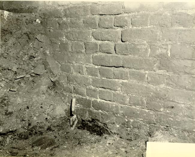 PLATE III. Detail of Scott Cellar brickwork, interior of West Wall. Note burnt board to right of trowel. 58-G.B.-9620
The presence of a quantity of metallic slag scattered through the soil in the vicinity of the furnace suggests that metalworking had been carried out nearby. In addition, one must consider the presence of numerous small fragments of waste iron which were similarly scattered, some of them being found within the confines of the chimney. Yet another fragment of iron was found sealed beneath a mortar repair inside the entrance channel to the furnace. It might, therefore, be suggested that both features were associated with ironworking - although no parallel has yet been found.
Assuming that the deposits of metallic slag were associated with the work carried on in the vicinity of the chimney and furnace, it follows that any dating evidence for the deposition of the slag will be an indication as to a date at which the structures were in use. Fortunately this dating evidence was forthcoming, for a quantity of slag was found in a sealed stratum (E.R.104A) south of the southwest corner of building "B". The layer contained a profusion of rusted and vitrified slag, fragments of a beverage bottle dating c.1770-1800 (Pl. XV, No. 2), creamware, delftware, hand-painted Staffordshire wares and transfer-printed white earthenware bringing the top date no earlier than a-1830. More significant were the finds from the layer beneath the slag stratum (E.R.104B) which included sherds of creamware, delftware, brown stonewares, bottle fragments, slate and two sherds of hand painted "Staffordshire" wares, one overglaze, the other underglaze, but both dating no earlier than c.1810. It follows, therefore, that the slag cannot have been laid down until that date, and in all 40 probability some while after it. This fits admirably with the dating suggested by finds from the slag layer itself, i.e. c.1830.
It may or may not be significant that fragments of waste iron were found towards the front of the lot in post hole "E" and in the pit associated with it (E.R.88, Pl. XX, Nos. 6-8), and whose sealing dates could not have been earlier than c.1820, yet no later than the building of the nineteenth century store which more recently became the Chamber of Commerce building. In short it may suggest that ironworking was carried out on the site after the destruction of the Scott house and prior to the building of the store.
Attention must also be drawn to the three post holes and post molds extending southwest from the furnace "E", all of which contained either slag or iron waste, while one of them, "Y" contained artifacts dating up to the mid-nineteenth century. It might be suggested, perhaps, that these holes were associated with the furnace complex and that both it and they had ceased to serve any useful purpose by the middle of the century.
The only evidence pointing to an early construction date for the furnace comes from a group of finds sealed beneath the mortar repair on the floor of its entrance flue. In a deposit of dirty gray clay silt (E.R.55) were found sheep, beef and chicken bones, a fragment of a revolutionary bayonet blade, part of the flat tang of a colonial knife handle to which bone blades had been riveted (Pl. XXI, Nos. 1 and 3). and one fragment of an English white saltglaze tankard dating c.1740-60. Of particular interest was part of a heavy iron hinge which had been folded back on itself. (Pl. XXI, No. 2). It is reasonable to assume that the furnace fell into a state of disrepair and was used, for a short time, 41 as a tip for refuse. The absence of the southern wall of the entrance flue (although the matrix in the clay in which it bad sat remained) suggested that the structure may have been partially dismantled and the bricks reused elsewhere. In support of this theory, one may draw attention to the fact that evidence of mortar repairs to the upper courses of the main structure in the nineteenth century suggested that the super-structure of the furnace had also been dismantled. It could be suggested, perhaps, that the furnace had been in existence in Scott's time and that it bad been abandoned after his death only to be rejuvenated and reused during the first half of the nineteenth century.
It was found that the furnace had been constructed in such a manner that it fitted exactly within a hole which had been dug for it, the brick walls and piers being constructed from the inside and pressed against the clay, the mortar squeezing out between the bricks and even being smeared against the face of the clay. On the inside, however, the mortar had been neatly trimmed. Shell was found in the mortar both of the primary construction of the furnace and in the repair to the north wall close to the western opening. The shell in the latter, however, was somewhat unevenly distributed and specimens submitted to Messrs. Moorehead, Bullock and Buchanan were judged to contain no shell and could have been accepted as limestone mortar of the nineteenth century.
The mortar repair mentioned above, along with mortar floor and southern side of the western entrance to the furnace were all found to be identical, making use of lumps of limestone mortar, fragments of wall plaster and even complete oystershells. 42 The mortar itself did contain, however, some shell - although it was clearly of nineteenth century date.4
While considering the mortars used in the construction of chimney "D" and furnace "E", it may be pertinent to note the discovery of two deposits of burnt shell and bone, one directly outside the chimney to the west and the other just south of the southeast corner. When first discovered it was thought that the deposits might indicate the burning of lime on the site in the eighteenth century. But after the shell-laden strata had been removed, it was found that they overlay artifacts dating no earlier than c.1840. An exploratory cutting through the strata to the rear of the chimney showed the shell stratum lying five inches below modern grade and one and one-half inches in thickness. The layer beneath the shell was explored to a depth of one foot, three inches (i.e. below the level of the base of chimney "D") and was found to be of a dirty gray, clay soil containing iron nails, small pieces of metallic slag and fragments of ceramics, the most significant of which was a small sherd of Ironstone china (E.R.51). Another cutting through the oyster deposit to the southeast of the chimney revealed similar stratigraphy, the lower level containing not only a group of nineteenth century fragments, but also an interesting assemblage of Colono-Indian sherds, most, if not all of them, coming from a single broad-rimmed bowl or dish (E.R.52, Pl. X, No. 12). It was clear that there had been considerable disturbance of this underlying soil in the nineteenth century and that the shell stratum could not possibly have been of eighteenth century date.
43No parallels for the design of the furnace have yet been found and, indeed, the term furnace is only used loosely. The absence of intensive burning on the inside did not encourage the belief that the fire, if set inside, would have emitted any great heat. The only traces of burning were confined to mortar in the inner face and to the mortar between the bricks extending into the joints no more than half an inch, while the bricks themselves were undamaged and exhibited no evidence of vitrification. The channels or flues on either side of the structure opened from within it and although running to an angled exit flue to the east, also opened into the chamber at the eastern end. Evidence of burning was found on the mortar lining of the exit flue and on a pad of mortar beyond it within the confines of chimney "D".
It has been suggested that a large, conical iron pot (possibly similar to the example in the Palace kitchen court) may have been set inside the so-called furnace chamber. If the pot contained the fire as well as the substance to be melted, it would be reasonable to expect that intensive heat would only penetrate sufficiently to redden the mortar of the supporting walls. However, the theory would not affirm the belief that the structure was used in ironworking, for the heat needed to melt the iron would also have melted the pot. Such a theory would also fail to explain the purpose of the elaborate side channels.
Following a report on the re-excavation of the furnace in the Daily Press, Mr. J. Kobelbauer of Williamsburg wrote to Mr. A. E. Kendrew describing a square furnace which had existed in his father's two hundred year old cabinet shop which bad been used to 44 dry wood, to warm timber for glue joints and for beating boards prior to veneering. Mr. J. Kobelbauer's sketches of the furnace (Aug. 11, 1958) are preserved in Central Files, but do not indicate any obvious parallel between the Kobelbauer furnace and the example found on the Scott site.
The chimney "D" was apparently free standing, for no traces of an accompanying structure were located. It could be suggested, therefore, that it was specially constructed for an industrial purpose and had never been part of a domestic building. The surviving three courses of informal bond, making use of fragmentary bricks; care only being taken to ensure an even face on the interior. The mortar contained shell and suggested that the structure was of eighteenth century date -- although no stratigraphy survived to support or deny this belief.
On the existing evidence it could be suggested that both furnace and chimney were constructed at the same time to serve a purpose of an undetermined but specialized nature. It may also be reasonable to suggest that some sort of roof, supported on piles or square cut timbers, had extended west from the chimney to protect the furnace from the elements. The absence of post holes or foundation piers does not preclude the existence of such a roof, for the supports could reasonably have rested on the ground and not in it.
When considering the furnace and chimney complex, attention should be drawn to the Coke Office site where a smaller, apparently free standing chimney of eighteenth century date was found in association with quantities of slag. Notice should also be taken of another furnace structure found to the rear of Chowning's Tavern.
EARLY NINETEENTH CENTURY BRICK FOUNDATION TO REAR OF SCOTT HOUSE - Archaeological data
Building "B"
On the west fence line of the lot and sixteen feet south of the Chamber of Commerce building were found the partially robbed remains of a building with a brick foundation eight and one-half inches in thickness, the structure being eighteen feet, three inches in width and twenty-eight feet, six inches in N/S length. The mortar was a pale yellow and devoid of shell, the bond informal, while a specimen brick measured eight and three-fourths inches by four and one-half inches by two and seven-eighths inches. Both southeast and southwest corners survived intact and overlay ceramic fragments dating from the third quarter of the eighteenth century (E.R.107). Valuable dating evidence was provided by the contents of a trash pit bridged by the south foundation of building "B", from which came a small quantity of sherds, including creamware, Whieldon ware, Delft and white saltglaze which indicate that the pit dates from c.1770-1780 (E.R.109). This, then, provides a date post quem for the construction of building "B".
A quantity of metallic slag accompanied by rusted iron nails and one fragment of iron waste was found in a three inch layer outside the southwest corner of building "B". Finds from this stratum, laying one foot, seven inches below the modern grade, included English transfer-printed and hand-painted wares which, are unlikely to date prior to c.1830 and possibly up to c.1850. (E.R.104A) Finds from clay soil beneath the slag layer (E.R.lo4B) were predominantly of the late eighteenth century but were given a dating c.1810-1820 by the presence of a small fragment of hand-painted
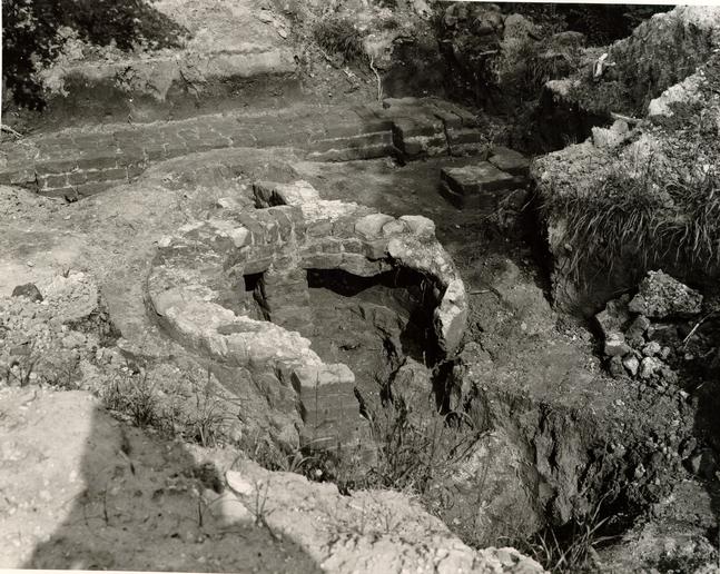 PLATE IV: Furnace and Chimney Complex as Revealed in 1955. From the West. 55-G.B.-1019.
46
English white earthenware of that period. Broadly speaking, therefore, it would seem reasonable to date the deposition of the slag stratum to the second quarter of the nineteenth century.
PLATE IV: Furnace and Chimney Complex as Revealed in 1955. From the West. 55-G.B.-1019.
46
English white earthenware of that period. Broadly speaking, therefore, it would seem reasonable to date the deposition of the slag stratum to the second quarter of the nineteenth century.
Fragments of ceramics and glass found in the back filling of the robbed foundation trenches (E.R.98). as well as the artifacts found in the soil overlying the surviving foundation remains, suggest that building "B" was destroyed at some time in the mid-nineteenth century. However, it must be borne in mind that evidence of this kind should be treated with extreme caution. It would be perfectly possible for the building to have been destroyed in the present century and for the back filling to contain no items dating any later than the given date. Nevertheless, in the absence of evidence to the contrary, the mid-nineteenth century date may be considered reasonable.
STRUCTURE PREDATING BUILDING "B" - Archaeological data
Outside the southeast corner of building "B" was found a thin spread of shell mortar running in a N/S strip one foot, four inches in width. The mortar was partially covered by the foundation of building "B", but extended eleven and one-half inches east of it and was traced for a distance of one foot, three inches in a northerly direction, having first appeared seven inches north of the foundation's southeast corner. It might be suggested, therefore, that the early nineteenth century building rested approximately on the site of a previous structure. Unfortunately, it was not possible to pursue the mortar spread northward for fear of undermining a Colonial Williamsburg fence and damaging the roots of a tree standing directly beyond it. A trench dug north of the tree on the line of building "B"'s east wall revealed no trace of the
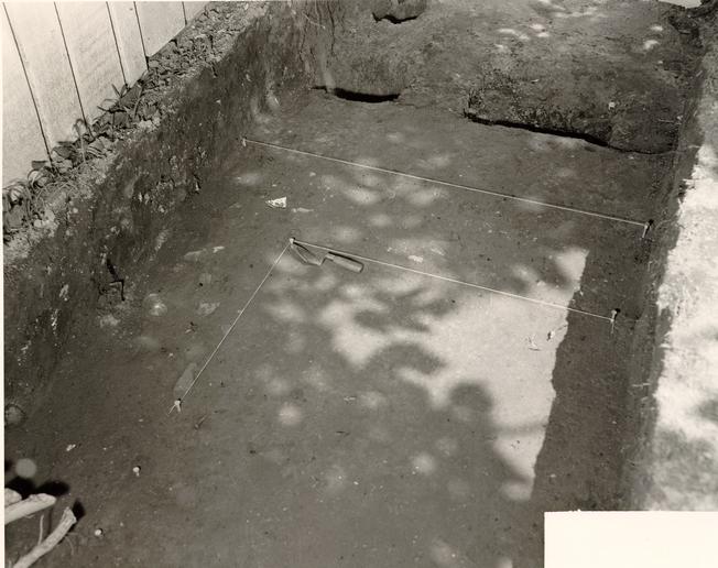 PLATE V. Robbed Remains of N.W. Corner of Building "B",
58-G.B.-964.
47
earlier spread. Artifacts directly overlying the mortar spread were consistently of the latter years of the eighteenth century. (E.R.103).
PLATE V. Robbed Remains of N.W. Corner of Building "B",
58-G.B.-964.
47
earlier spread. Artifacts directly overlying the mortar spread were consistently of the latter years of the eighteenth century. (E.R.103).
In support of the supposed existence of an earlier structure on this portion of the site.one might take into consideration the presence of numerous bricks with shell mortar attached which were found in the trash pit (E.R.109) which lay beneath the south wall of building "B". It could be argued, of course, that these bricks came from the damaged superstructure of the furnace - and there is no denying that this theory is as good as another.
COMPARATIVE BRICK SIZES FROM STRUCTURES B, D, & E
Comparative brick measurements from various features on the site are listed below; but it will readily be seen that there are no obvious conclusions to be drawn from them.
| 8-¾ x 4-¼ x 2-3/8" | Samples from basic structure |
| 8-½ x 4 x 2-¼" | of the furnace. |
| 8-½ x 4-1/8 x 2-¾" | Sample from furnace mouth. |
| 8-½ x 4-¼ x 2-½" | Samples from south wall of |
| 8-¾ x 4-¼ x 2-½ | chimney foundation "D". |
| 8-¾ x 4-3/8 x 2-¼ | Sample from trash pit c-1770-80. (E.R.109). |
| 8-½ x 4-1/8 x 2-3/8" | Sample from S. foundation of building "B". |
FOUNDATION COMPLEX ON EASTERN HALF OF LOT 354
In the hope of recovering data which would determine the date of construction for a rectangular structure facing Bruton
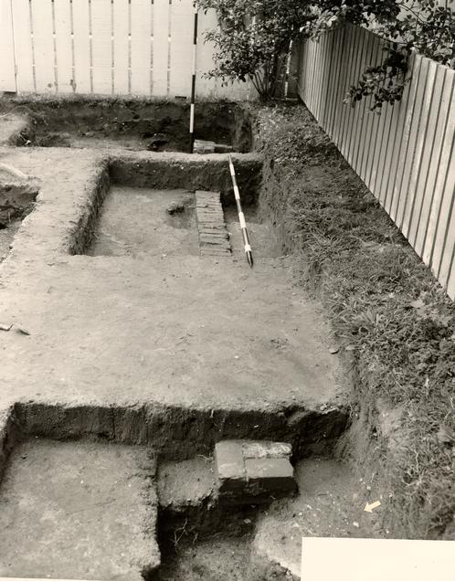 PLATE VI. South Wall of Building "B" with Earlier Mortar Spread Arrowed. From the East.
58- G.B.-1018.
48
Parish Church, a partial re-excavation was undertaken, the results of which were less than satisfactory.
PLATE VI. South Wall of Building "B" with Earlier Mortar Spread Arrowed. From the East.
58- G.B.-1018.
48
Parish Church, a partial re-excavation was undertaken, the results of which were less than satisfactory.
The structure had been previously excavated under the direction of Mr. J. M. Knight, and bad been found to lie parallel to Duke of Gloucester Street at a distance of sixteen feet, nine and five-eighths inches from the street. The foundations were known to have been much damaged by modern gas and water pipe laying as well as by later building operations. The latter activity relating to the temporary sojourn of the James Galt Cottage on the site had resulted in the total destruction of the southwest corner and most of the south wall of the earlier structure. It was decided, therefore, to re-excavate the northwest corner in the hope that part of it would have remained undisturbed either by the Galt Cottage Operation or by Mr. Knight's trenching. Consequently, a ten foot grid was laid out so as to ensure that one square lay directly over the corner and included also a massive brick foundation which protruded westward from the west wall.
The excavated square was bounded on the south by the foundation for the cellar of the Galt Cottage, included the concrete footing for that structure's porch which overlay the earlier foundations, as well as a section of walling which extended west from the supposed northwest corner of the brick foundation.
It had been assumed by Mr. Knight that all foundations on this section of the lot were of post colonial date. The 1958 excavations served only to confirm this opinion. He further assumed that the section of wall No. 1 (see plan), was part of the same structure and of the same date as N/S wall No. 2, although the latter stopped four inches short of the E/W section. The re-excavation seemed also to confirm this opinion, although it failed to explain 49 the four inch gap between foundations one and two.
Unfortunately, the Galt Cottage foundation laying had resulted in the destruction of the south face of the brick foundation No. 3, and it was therefore impossible to be certain whether one was dealing with a short two bricks in width or with a solid foundation extending to an indeterminate distance in a southerly direction. It was found that wall No. 2 continued across the east end of No. 3, there being a straight joint on a line with its western or exterior face. To the west of this joint foundation No. 3 dropped one course, continuing at that level until it reached its western extremity. At that point the northwest corner was undamaged, but as previously stated, the south face and southwest corner had been trimmed, thus making it impossible to be certain whether the foundation merely stopped at that point or whether turned south again.
No satisfactory explanation of the purpose of foundation No. 3 has been forthcoming. The suggestion that it formed part of a solid base for a chimney seems to be the most plausible, although th( probable proportions of four feet, nine inches by six feet are somewhat unusual. The closest parallel is provided by the chimney of The Quarter of Francis Street which dates from the late eighteenth century and measures four feet, by five feet, six inches. The second possible parallel for the proportions of the Scott foundation is apparently the chimney of the Bracken House, close by the Quarter, which has a base measurement of three feet., six inches by six feet.5
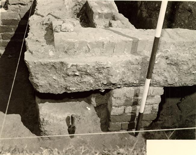 PLATE VII. Galt Cottage Porch overlying Earlier Brick Foundation. From the West. Builders' Trench Arrowed. 58-G.B.-1285.
Dating evidence for foundation No. 3 is provided by a five inch builder's trench along the north face of the brickwork. This trench cut through disturbed soil containing ceramic fragments which could not date before the early nineteenth century. (E.R.113B). Any builder's trench which may have existed along the west face of foundation No. 3 had been removed by previous excavation. However, a comparable trench was found running N/S along the exterior west face of foundation or Wall No. 2; but here the trench had been back-filled with dirty soil which blended too well into the surrounding strata that it was not possible to state with certainty that the trench cut completely through the early nineteenth century disturbance.
Foundation No. 1 was found to step up from No. 2 and only survived to a depth of two courses. Foundation wall No. 4, which continues west on the same line as No. 1 rises a further course and has no shell in the mortar whereas No. 1, 2, and 3 all contain shell. It will be evident from an examination of Pl. VIII that No. 4 lies in a trench which extends along its south face a width of six to seven inches. However, the foundation does not lie on the bottom of the trench, but rests on soil which had been back-filled into it. In the foreground of Pl. VIII one can see where part of the wall has been removed and the trench fill extracted to expose the bottom of that trench. It may be suggested, therefore, that a trench for a wall extending from No. 1 was dug at any earlier date and that the plan was abandoned and the trench back-filled. Subsequently the project was revived and a later wall was laid on the same line as the previous trench. Thus it can be supposed that buildings represented by the foundations No. 1, 2 and 3 and by No. 4 were in existence contemporaneously.
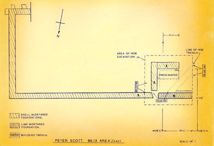 Plan - Peter Scott Blk. 13
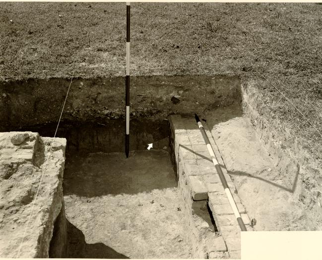 PLATE VIII. 19th Century Foundation N. of Galt Cottage with Builders' Trench Arrowed. From the East. 58-G.B. 1280.
51
Furthermore, on the evidence of the builder's trenches quoted above, neither structure can have been of colonial date.
PLATE VIII. 19th Century Foundation N. of Galt Cottage with Builders' Trench Arrowed. From the East. 58-G.B. 1280.
51
Furthermore, on the evidence of the builder's trenches quoted above, neither structure can have been of colonial date.
At Mr. Bullock's request a further ten foot square of the previously laid out grid was excavated to the northeast of the square previously discussed (see frontispiece). It was thought that the new area would span the colonial building line facing Duke of Gloucester Street and expose traces of any structures which may have stood behind it. It was found that the square was riddled with disturbances caused by the laying of drains, gas and water pipes as well as by Mr. Knight's earlier cross-trenching. No trace of a colonial structure was to be found.
TRASHPITS ON THE PETER SCOTT SITE
Few pits of any importance were located during the 1958 excavations and none of the artifacts found could claim to be of unusual significance. The principal deposits were as follows:
| E.R.75. | A rectangular pit five feet, seven inches in length, cutting through the north wall of the Peter Scott chimney and causing the rear wall of that chimney to be trimmed on the inside. The pit extended into natural clay, terminating at a depth of two feet, three inches below the E/W datum line. (See plan, figs.) Finds included a small number of ceramic sherds dating into the early nineteenth century, a large piece of slag or clinker and an iron chisel (Pl. XX, No. 5). |
| 52 | |
| E.R.74. | A small rectangular pit three feet, two inches south of the Chamber of Commerce south wall, partially exposed by trenching (see Fig. 4). The pit measured two feet, nine inches in a N/S direction and two feet plus, E/W, terminating at a depth of four feet below datum. The filling proved to be divided into two parts; dirty brown soil over a primary silting of washed clay. All finds came from the upper deposit and comprised two small fragments of Delftware, one coarse sherd and two fragments of tobacco pipe stems, all dating from the colonial but too small to be dated any more closely than to the era c.1700-1770. |
| E.R.73. | A second rectangular pit five feet, three inches south of E.R.74, measuring three feet in length and one foot, ten inches plus in E/W width. (See Fig. 4). The deposit comprised two strata of dirty clay and of brown soil, the latter yielding the only artifacts. These comprised six fragments of eighteenth century bottle glass and two sherds of Westerwald stoneware from a single vessel, which may have been either a chamberpot or a storage jar. (Pl. XII, No. 9). These finds may only be dated as closely as were those in the preceding pit. It seems possible, however, that the two pits were dug for some purpose other than as receptacles for trash and were of the same date. |
| E.R.108. | An oval trash pit fifteen feet west of the furnace mouth and six feet, six inches south of building "B". The dirty soil filling contained fragments of bricks bearing oyster shell mortar, and terminated at three feet, two and one-half inches below the modern grade. Artifacts included a rectangular iron plate of uncertain purpose, part of a spade blade (Pl. XXI, No. 6), a fragment of late 53 eighteenth century bottle glass and two joining sherds of Nottingham stoneware of similar date. |
| E.R.99. | A small circular pit six feet, six inches west of the furnace mouth and five feet, six inches south of the southeast corner of building "B", terminating in natural clay at two feet, seven inches below the modern grade. Diameter of the pit, one foot, nine inches. Ceramics from the deposit include shell-edged creamware (Pl. X, No. 1), a body sherd from a saltglaze tankard of good quality, c.1740-60, (Pl. XI, No. 13), a rim sherd from a plain delft bowl of wash basin type, as well as a single sherd of brown, lead-glazed coarse ware. The top date for the group would appear to be c-1770-80. |
| E.R.109. | An irregular shaped pit spanned by the south wall of build[ing] "B", commencing six feet from the latter's southwest corner. The pit two feet, six inches in E/W length and with a similar measurement at its greatest N/S width, and terminating at three feet, eight inches below the modern grade. Finds included part of a bottle base of the period c.1740-60, as well as small fragments of Delftware, saltglaze, creamware and Whieldon ware. The top date for this group is consequently set at c.1770-80 and is important in that it provides a date post quem for the construction of building "B". |
| E.R.94. | This number refers to a pit which seems likely to exist within the laundry yard directly to the west of the Peter Scott fence line and which was discovered when Colonial 54 Williamsburg carpenters were rebuilding the existing fence. The digging of a new post hole (see plan, Figs.) brought to the surface a fragment of a coarse Buckley ware cooking vessel and a wine glass stem which may be attributed to the decades 1730-60. (Pl. XIV, Nos. 5 and 11). The pit was not explored. |
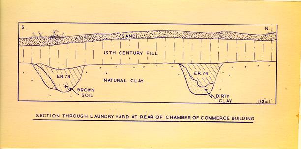 Section through Laundry Yard at Rear of Chamber of Commerce
THE ILLUSTRATED ARTIFACTS
The artifacts found during the Peter Scott excavations were, on the whole, of little significance, the majority being extremely fragmentary and of post-colonial date. The items illustrated in the following plates have been selected on the grounds that they are representative, unusual or significant as dating evidence for the deposits in which they were found. Many items had still to be catalogued at the time that this report was completed. Consequently the absence of a catalogue number does not necessarily indicate that the object was unworthy of same. The suffix 13 J4 after the number signifies that the item was found during the excavations 1955 or 1958 in deposits to the east or south of the Chamber of Commerce building, while 13E indicates a find from the ground beneath that structure.
- 1.Rim sherd of feather-edged creamware plate, c.1770-80. E.R.99.
- 2.Section through small, feather-edged creamware plate, c.1770-80. E.R.71C.
- 3.Rim sherd of feather-edged creamware plate or dish of large size. c.1770-90. E.R.71D.
- 4.Teapot spout, fine quality creamware. c.1770-80. E.R.71C.
- 5.Saucer of pale creamware, small, angular and slightly inturned footring, the glaze yellow within. c.1780-90. E.R.72C.
- 55
- 6.Flat rim sherd from creamware plate or dish, the glaze somewhat yellow. Late eighteenth century. E.R.72C.
- 7.Basal sherd from creamware plate stamped with star mark. A similar mark appears on the base of a creamware coffeepot along with name WEDGWOOD and which is dated c.1777. See English Cream-Coloured Earthenware by Donald C. Towner, P. 92 and Pl. 85. E.R.72C.
- 8.Rim sherd of deep creamware plate in debased "Queen's" style, vestigial footring. c.1780-90. E.R.72C.
- 9.Rim sherds similar to the above, but slightly less yellow in color. c.1780-90. E.R.72C.
- 10.Scalloped rim from creamware plate, the glaze somewhat yellow. c.1770-80. E.R.71D.
- 11.Section through hand-made, Colono-Indian bowl, the rim flat and everted, the ware shell-tempered and stick or pebble burnished. Third quarter of eighteenth century. E.R.72E-F.
- 12.Flat rim fragments from soup bowl (?) of Colono-Indian pottery shell-tempered and stick or pebble burnished. Third quarter of eighteenth century. E.R.52.
- 13.Handle, probably from chamberpot of Colono-Indian pottery, shell-tempered. Third quarter of eighteenth century. E.R.103
- 14.Body fragments from bowl of Colono-Indian pottery, shell- tempered and stick or pebble burnished. Possibly from same vessel as No. 11. Third quarter of eighteenth century. E.R.7 E-F.
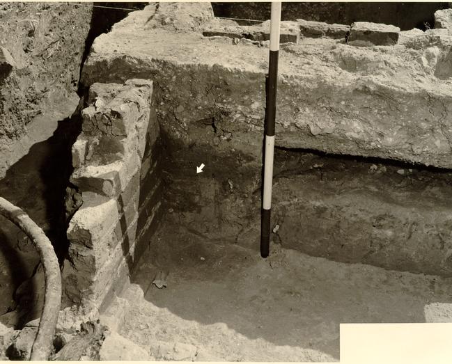 PLATE IX. Brick Foundation under Galt Porch. Builder's Trench Arrowed. From the North. 58-G.B.-1286.
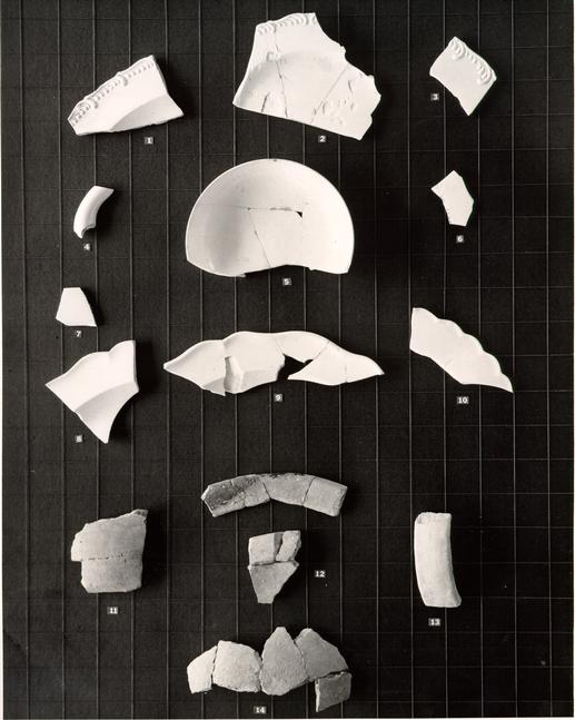 PLATE X. Creamware & Colono-Indian Pottery. 58-G.B.1058.
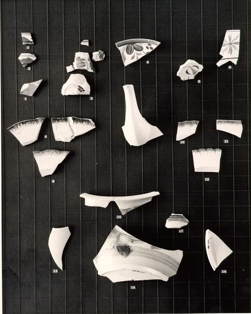 PLATE XI. Post-Colonial White Earthenware, Scratch-Blue and White Saltglazed Wares. 58-G.B.-1054.
PLATE XI
- 1.Rim sherd from hand-painted white earthenware, Staffordshire cup decorated in yellow, blue, brown and green in leaf motif. Early nineteenth century. E.R.72C.
- 56
- 2.Rim sherd comparable to the above., but with the top band of yellow somewhat lower, color and ornament otherwise similar. Early nineteenth century. E.R.88.
- 3.Fragments of hand-painted, white earthenware cup, Staffordshire (?) decorated in floral motifs in brown, green and orange, with a band of yellow edged in brown below the rim on the interior. Decoration in style of Pl. 12 l9th Century English Pottery & Porcelain, Faber, 1952, by Geoffrey Bemrose, a pitcher ornamented in peasant style and dated 1814. E.R.71C.
- 4.Rim sherd of saucer, hand-painted,, English white earthenware of debased form, ornament in blue-grey, maroon, yellow and brown within a wide blue border. c.1820-40. E.R.98.
- 5.Basal sherd of lead-painted white earthenware bowl, Staffordshire (?), decoration in orange and brown. The vessel has an angular footring and the glaze is markedly blue in the crevices. Early nineteenth century. E.R.83.
- 6.Rim and body fragments of white earthenware bowl, Staffordshire (?), hand-painted decoration in blue, orange and brown, a brown band below the rim on the interior. Early nineteenth century. E.R.79.
- 7.Body sherd of white earthenware bowl, marbled decoration on the interior in shades of yellow, grey and blue. Early nineteenth century. E.R.71D.
- 7a.Teapot spout of English, white earthenware, the glaze appearing blue in the crevices and spotted accidentally with 57 cobalt. Overglaze maroon paint on spout lip. Nine straining holes through wall at junction of spout and body arranged in diamond pattern. Early nineteenth century. E.R.71B.
- 8.Rim sherds from blue-edged, white earthenware dish, Staffordshire (?), decorated with molded, fronded ornament. c.1790-1800. E.R.72C.
- 9.Rim sherd of blue-edged, white earthenware plate, Staffordshire (?), decorated with molded feather motif along the edge; the junction of rim and wall markedly angular, the former consequently appearing somewhat dished. c.1790-1800. E.R.72C.
- 10.Rim sherd of blue-edged, white earthenware, Staffordshire debased shell-edge motif, the glaze appearing green on the underside suggesting that a green-edged plate had rested directly below the blue in the kiln. c.1790-1800. E.R.72C.
- 11.Rim sherd from octagonal blue-edged dish of white earthenware, Staffordshire (?), ornamented with shell motif. Thin body of good quality. c.1780-1800. E.R.96.
- 12.Rim sherd of blue-edged white earthenware plate, Staffordshire ornamented in shell motif and with scalloped edge. c.1780-1800 E.R.72C.
- 13.Body sherd of thin, English, white saltglaze tankard. c.1740-60. E.R.99.
- 14.Basal sherd from large cylindrical vessel of uncertain form of English, white saltglaze. The body ornamented with a single groove above a beaded footring, the base slightly raised within it. Approximate diameter at base, nine inches. E. R.99. c-1740-60.
- 15.Rim sherd of English, scratch-,blue chamberpot, lead glaze 58 over saltglaze body, the rim everted and thickened and the body decorated with a band of incised lines below the rim. Third quarter of eighteenth century. E.R.71C.
- 16.Body and basal fragments of English, scratch blue, chamberpot, lead-glaze over saltglaze body; a small, angular foot and the base raised within. The body ornamented with incised foliate motifs and with cobalt roughly applied over it; a band of incised lines above the base forming a terminal for the decoration. It is probable that this base is part of the same vessel as rim fragments No. 16. Third quarter of eighteenth century. E.R.71C.
- 17.Basal sherd from small English, scratch blue cup or vase, lead glazing over saltglaze body. No footring and with a band of incised lines above the base filled with roughly applied cobalt. Third quarter of eighteenth century. E.R.72C.
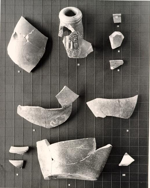 PLATE XII. Brown and Grey Stonewares of the Colonial Period. 58-G.B.1060.
PLATE XII
- 1.Neck and rim fragments from large brown stoneware Bellmarine of Rhenish origin. The rim thick and the cordoning debased, the mask of poor quality; the handle oval in section, triple reeded on the upper surface and with two small, square holes pressed into it close to the junction of handle and neck. c.1680-1700. Found during 1955 excavations, provenance uncertain, but probably from Scott cellar. l3J4.
- 2.Body fragments with base of handle from large brown stoneware Jug, possibly Yorktown. The body slightly underfired and yellow on the interior. Mid-eighteenth century. E.R.71D.
- 59
- 3.Small body sherd from excessively glazed brown stoneware vessel of uncertain form. Probably Yorktown. Probably second to third quarter of eighteenth century. E.R.96.
- 4.Junction of handle and body from brown stoneware jug, the glaze slightly purplish in Fulham style, the interior light, speckled brown. Mid-eighteenth century. E.R.71D.
- 5.Rim sherd of brown stoneware storage jar in Fulham style; the rim slightly offset and recessing internally to take a lid. A vessel of similar form was found in a context of c.1765-1770 at Rosewell in Gloucester County. E.R.72C.
- 6-8.Body and basal fragments from a large brown stoneware jug or storage jar, the fragments heavily burnt and therefore discolored. Base diam. approximately six inches. Found in destruction stratum of Scott cellar, i.e. Jan. 1776. E.R.72E-F.
- 9.Rim and upper body sherds from Westerwald chamberpot, or possibly storage jar, of grey stoneware decorated with applied medallions, highlighted and within borders of cobalt. This example of poor quality and probably belonging to the third quarter of the eighteenth century. E.R.73.
- 10.Basal fragments from Westerwald chamberpot of grey stoneware, a molded band filled with cobalt above the base and the base itself somewhat pink. Third quarter of eighteenth century. E.R.97.
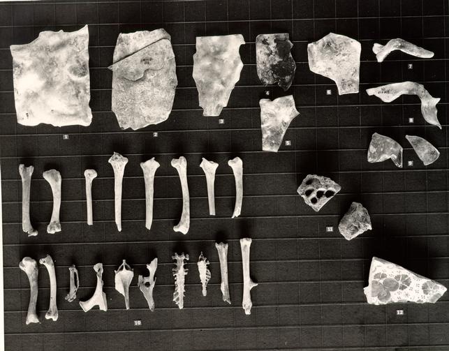 PLATE XIII. Relics from the Floor of the Scott Cellar.
PLATE XIII
- 1.Rectangular piece of window glass much burned in destruction of Scott house. The metal pale green one-tenth of an inch in thickness. E.R.71F.
- 60
- 2.Examples of window glass of differing quality fused together in the Scott fire. The larger fragment one twenty-fourth of an inch in thickness, the smaller one twelfth of an inch. E.R.71F.
- 3.Fragment of green window glass one-twelfth on an inch in thickness; details as above.
- 4-8.Further fragments of burnt and twisted window glass, green metal; details as above.6
- 9.Two fragments of clear, lead glass one-eighth on an inch in thickness and of uncertain purpose. E.R.71F.
- 10.Examples of chicken bones found pressed into the clay floor of the Scott cellar. E.R.81A.
- 11.Examples of mud-daubers' nests, baked in the burning of the Scott cellar. Impressions of wood on the backs of the nests indicate that they were built against timbers possibly the joists of the floor over the Scott cellar. This would indi6ate that the timbers were horizontal and at least one and one-half inches in thickness. It might be suggested, therefore, that the joists above the cellar were not concealed by a ceiling. E.R.72G.
- 12.Basal fragment from English Delftware dish decorated with an elaborate floral motif in cobalt; the foot heavy and V-shaped. c.1700. Fragments of a plate with similar decoration., probably by the same hand, were found on the site of Marot's Ordinary. 3C-90-9L. See Colonial Williamsburg Archaeological Report on Site 9, 1955, Pl. IV, No. 2. Scott reference: E.R.71F.
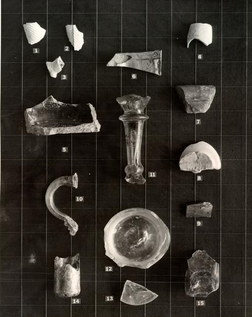 PLATE XIV. Tobacco-Pipes, Ceramics and Glass from Various Deposits.
PLATE XIV
- 1.Fragment of clay tobacco pipe bowl ornamented with molded, diagonal ribbing. Late eighteenth or probably early nineteenth century. E.R.71A.
- 2.Fragment similar to preceding but showing mold mark facing stem. E.R.91.
- 3.Base of pipe bowl with spur and part of bowl decorated with ribbing as above. No visible maker's initials. E.R.91.
- 4.Bowl fragment of clay tobacco pipe, large size. Early nineteenth century. E.R.72C.
- 5.Basal fragment of cooking or storage vessel of North Wales. Buckley ware, black or dark brown lead glaze over pink surface, variegated clay of pink and yellow. Eighteenth century, colonial period. E.R.94.
- 6.Rim sherd from silver lustre surfaced bowl of uncertain form. The rim apparently flat and everted; the body purple and fired at high temperature. Presumably early nineteenth century. E.R.72C.
- 7.Rim sherd from large cream-pan, pale brown lead glaze over pinkish-red body, the rim thickened and slightly incurving above a groove. Possibly from the West of England. Seventeenth or eighteenth century. E.R.106.
- 8.Base of small Delft drug pot, thick tin glaze over pink body; the base very small and indicative of a late date. Probably third quarter of eighteenth century. E.R.107.
- 9.Rim sherd from vessel of uncertain form, thin brown glaze over pink to buff body. Possibly Buckley. Eighteenth century (?). E.R.107.
- 62
- 10.Lead glass handle from small jug, the metal pressed abruptly to the neck at the top but forming a rigaree type terminal in archaic form at the base. Probably Irish and dating from the first quarter of the nineteenth century. See English, Scottish and Irish Table Glass, Batsford, 1955, by Bernard Hughes, Pl. 300 for similar handle on larger jug. E.R.92. Unstratified.
- 11.Wine glass stem, lead metal, knop at junction of stem and foot, balustroid stem broadening at the top to an annular knop, the bowl spreading sharply outwards. A large tear or bubble at the base of the bowl and doming up into it, also a long and uneven tear extending from the lower knop to within half an inch of the upper, c.1730-60. E.R.94.
- 12.Base of heavy tumbler, lead metal, remains of pontil mark in center; base diameter: two and three-eighths inches, basal thickness: one-half of an inch. Probably second half of eighteenth century. E.R.71D.
- 13.Fragment of small lead glass foot, solid, possibly from Jelly glass or rummer. Second half of eighteenth century (?). E.R.72E-F.
- 14.Base of heavy and crudely made medicine phial, metal pale gree basal kick in form of small evenly formed dome - a late characteristic. Small conical basal kick. Second half of eighteenth century. E.R.79.
- 15.Base of small square bodied bottle, lead metal, pale grey-green. Small and uneven basal kick. Base measurement: one 63 and one-half inches by one and one-half inches. No parallel available, but archaeological associations indicate a terminal date in the late eighteenth or early nineteenth century. E.R.72C.
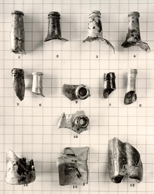 PLATE XV. 18th Century Beverage Bottle Fragments. 58-G.B.1055.
PLATE XV
- 1.Beverage bottle neck with small rectangular string-rim at level of mouth, metal olive green, the neck becoming somewhat bulbous below its center and then constricting above the shoulder. c-1765-90. E.R.72C.
- 2.Beverage bottle neck, very short with lip thickened and sharply down-tooled and with a round-sectioned string-rim below; metal a deep olive green with a few bubbles. c.1790-1810. E.R.l04A.
- 3.Beverage bottle neck, short, with lip thickened and down-tooled above a string-rim similarly down-tooled, metal a rich olive green. c.1790-1810. E.R.71C.
- 4.Beverage bottle neck, somewhat broadening at the shoulder, the string-rim close to the lip and down-tooled; the metal olive green. c.1740-60. E.R.72G.
- 5.Beverage bottle neck, the rim thickened and down-tooled into a string-rim which has declined into an almost flat collar; the neck slightly constricted above the shoulder; metal a deep olive green. Late eighteenth to early nineteenth century. E.R.72C.
- 6.Beverage bottle neck with string-rim tooled up towards lip. Metal pale olive green. Third quarter of eighteenth century. E.R.71C.
- 64
- 7.Beverage bottle neck, rim thickened and down-tooled over a small similarly down-tooled collar. The angular marvering of this example represents a development from No. 5 and is the hand-tooled parallel for the early mold-made bottle shape patented by the firm of Ricketts in Bristol, England. The metal a deep green. Early nineteenth century. E.R.82A.
- 8.Beverage bottle neck, thick mouth above a roughly applied and flattened string-rim; the neck narrowing above an almost non-existent shoulder. Vertical tooling marks on the neck and the metal olive green. French, late eighteenth or nineteenth century. E.R.98.
- 9.From disturbance over northwest robbed corner of building "B". Case bottle neck and shoulder, the neck short and the lip thickened and V-tooled the shoulder very slightly rising. The metal olive green. Second half of eighteenth century. E.R.72C.
- 10.Case bottle neck and shoulder, similar to the above, but with the lip less heavy and the metal a paler green. Second half of eighteenth century. E.R.72C.
- 11.Case bottle base, square and rising in a shallow cone with tubular pontil mark beneath, the latter overlying a cross-shaped mold-mark. Basal width: three inches. The metal olive green. Second half of eighteenth century. E.R.72C.
- 12.Beverage bottle base, small size, the bottom very thick and with only a slight, domed, basal kick, roughly pulled at one side. The body slightly spreading above the base and the metal olive green. Base diameter: three inches. Late eighteenth century. E.R.71E.
- 65
- 13.Base of beverage bottle with high conical kick and the body spreading slightly towards the shoulder. Traces of horizontal ribbing or tooling on the body. The metal olive green but the surface turned matt brown by decay. Base diameter: three and one-eighth inches. Probably French. Second half of eighteenth century. E.R.72C.
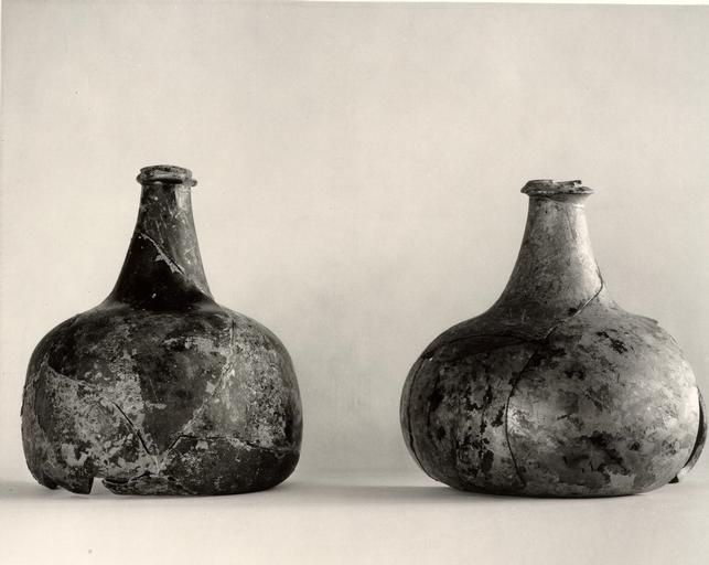 PLATE XVI. Early 18th Century Beverage Bottles from the Floor of the Scott Cellar.
PLATE XVI
- Left. Beverage bottle of early squat form, but the shoulder less weak than was usual at that time; the neck somewhat conical and the lip slightly everted above a flat string-rim. Swirled stress grooves on the neck, the base gently domed and the metal a pale, olive green, the surface now flaking and blackened by decay. Approximate parallels for the form are provided by an example in Guildhall Museum, London, bearing the seal "D.L.F.1708" and by another in the London Museum (of smaller capacity) with a seal marked "I.I.17O4" Height: six inches. Basal diameter: five and one-fourth inches. E.R.84C. Cat. No. 779-13E.
- Right. Beverage bottle of squat form common during the early eighteenth century, wide base and extremely weak shoulder and with neck somewhat conical. An uneven V-tooled string-rim close to the roughly struck lip. Shallow, domed basal kick. Height: five and three-fourths inches. Basal diameter: approximately six inches. c.1700-1720; E.R.84C. Cat. No. 780-13E.
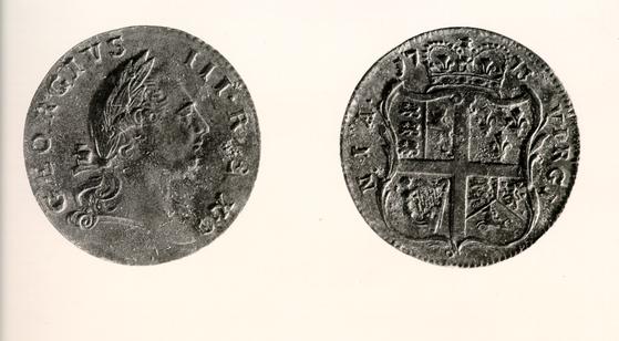 PLATE XVII. Virginia Halfpenny of 1773 from the Scott Cellar. E.R.71F. 58.-G.B.-1051.
PLATE XVII
- Obverse and reverse of Virginia copper halfpenny of 1773.
Obverse: Newman type 7., reverse: Newman type D. See 66 Coinage for Colonial Virginia, Numismatic Notes & Monographs No. 135, American Numismatic Soc., 1956, by Eric P. Newman. The coin has a smooth green patina but is virtually in mint condition. It should be noted that these 1773 coins were not issued in the colony until April, 1775. Diameter: one inch. E.R.71F. Cat. No. 781-13E.
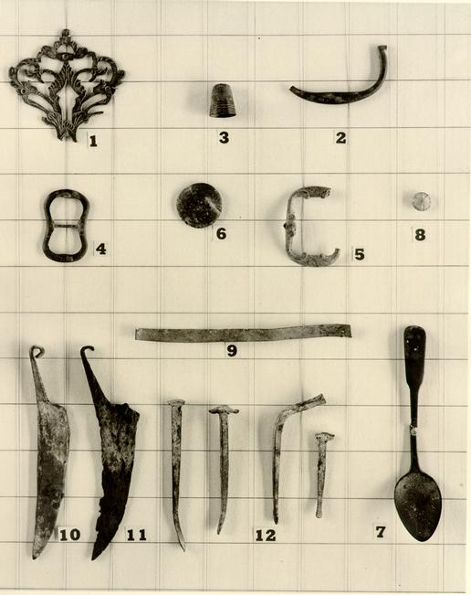 PLATE XVIII. Small Finds from the Vicinity of the Scott Cellar. 58-G-B-1053.
PLATE XVIII
- 1.Brass keyhole escutcheon in stylized foliate design. Three holes surviving for mounting to cabinetwork, black patina. Probably second half of eighteenth century. E.R.71D. Cato. No. 183-13E.
- 2.Brass drop handle from drawer, small pivotal lugs and the handle thickening at the center of its span. Eighteenth or nineteenth century. Cat. No. 784-13E. E.R.77 (overlying E.R.88).
- 3.Small brass thimble with wide zone of grooves and ridges at the base. Probably first half of nineteenth century. E.R.87.
- 4.Brass belt buckle of figure eight form, convex on the upper face and flat behind. A type common in the seventeenth, and eighteenth centuries. Cat No. 785-13E. E.R.84C.
- 5.Brass belt buckle, rising in the center and with iron cross bar. The interior edges at either end ornamented with molded scrolls and the surface adorned with engraved foliate decoration. Eighteenth century. E.R.72C. Cat. No. 782-13E.
- 6.Brass face from plain button, probably originally backed with bone. Second half of eighteenth century. E.R.72C.
- 7.Brass teaspoon, pointed bowl and with spatula handle. No marks. First half of nineteenth century. E.R.79.
- 67
- 8.Clear glass "stone" from item of cheap jewelry, the stone rounded on the back and the face cut to divide it into eight segments or pseudo-facets. Dating on archaeological evidence only. E.R.71D.
- 9.Strip of waste brass. E.R.72C.
- 10.Iron blade, small and thick, with tapering handle curled over at the end. The blade slightly concave on the back and the "cutting-edge" too broad to do anything other than scrape or score. Illustrated beside the Scott blade is another (No. 11) which was found in a trash deposit at Rosewell dating c.1765-70. Two slightly larger examples with the rolled terminal missing are in the Colonial Williamsburg collection and are numbered 9.604.2J2 and 9.640-17G3 respectively. Nothing is known of them. However, it has been suggested that tools of this type may have been used by brick-layers for scoring mortar. The Scott example was found in the destruction debris of the cellar in close proximity to a group of iron nails (No. 12) which were similarly well preserved. E.R.72E-F. Cat. No. 1319-13E.
- 11.Iron blade similar to No. 10. From excavations at Rosewell in a context dating c.1765-70. U.S. National Museum.
- 12.Examples of iron nails found in the destruction debris of the Scott building (see No. 10), hand-wrought and spatula ended. E.R.72E-F.
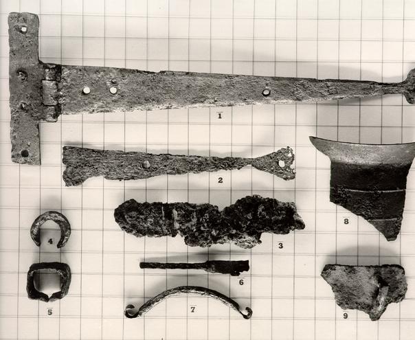 PLATE XIX. Iron Items from Various Deposits.
PLATE XIX
- 1.Large T-shaped hinge, iron, four nail holes in jamb portion and four others in the strap. When found the remains of three nails survived in the former, the longest being two and one-fourth inches in length. Prior to cleaning, it also appeared that the holes in the strap were countersunk, while those in the jamb section were not. That feature was still apparent after cleaning was completed. No marks. Archaeological evidence indicates dating Prior to 1776. E.R.72F. Cat. No. 1320-13E.
- 68
- 2.Fragment of strap hinge, iron, spreading terminal similar to the above. Eighteenth century. E.R.74. Cat. No. 1005-1[cut-off]
- 3.Part of iron binge, probably jamb section from T-shaped hinge too rusted to withstand cleaning. E.R.72C.
- 4.Part of thick, iron ring (?) of uncertain purpose. E.R.71C.
- 5.Rectangular iron band, the ends tapering at the center of one of the longest sides and probably originally drawn up into a hook. Width of wall fifteen-sixteenths of an inch. Possibly the base of a single tree hook. E.R.72C. Cat. No. 1003-13E.
- 6.Tang and fragment of blade from table knife, iron, the blade thickening at junction with tang, backed by a narrow collar. The [tang (?)] rectangular in section. The back of the blade rises in what might be termed a dorsal crest, a form typical of the eighteenth century and generally associated with the upswept and round ended blade. Late eighteenth century. E.R.72C. Cat. No. 763-13E.
- 7.Half of double hooked bit, iron, round sectioned, the ends flattened and rolled over to create link at the center of the mouth and for attachment to the cheek-piece. Archaeological dating only. E.R.71C. Cat. No. 1004-13E.
- 69
- 8.Rim and body fragment from iron, tripod-legged cooking pot of traditional form. The rim thin and flaring and the body decorated with horizontal bridged bands. The body one-eighth of an inch in thickness. Eighteenth century. E.R.71C. Cat. No. 777-13E.
- 9.Rim fragment from cylindrical iron cooking pot, presumably tripod-legged, small angular handles of degenerate form. Nineteenth century. From group of finds recovered by colored labor and of uncertain provenance. Associated finds dating to the late nineteenth century. Cat. No. 1001-13E.
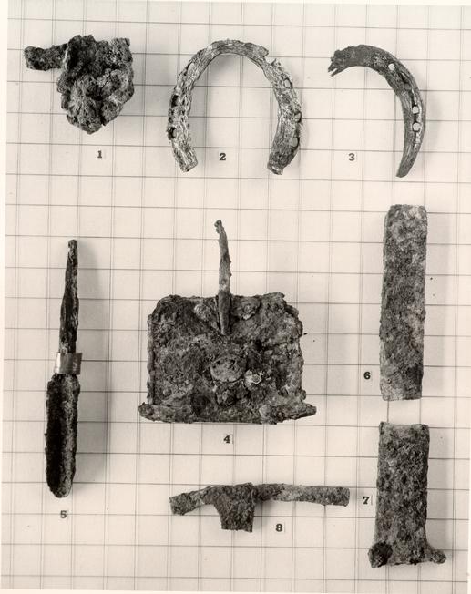 PLATE XX. Iron Items from Various Deposits. 58-.G.B.-1061.
PLATE XX
- 1.Iron object, much corroded and of uncertain purpose, possibly part of a currycomb. E.R.71B.
- 2.Iron horseshoe, upturned heel terminals, three nail holes on one side and four at the other, remains of groove running from heel to heel on the line of the holes. No evidence of toecap. Archaeological evidence suggests terminal date c.1776. E.R.72C. Cat. No. 997-13E.
- 3.Fragment of horseshoe of similar shape to the above, but without heels, the shoe narrowing almost to points. Four nail holes on surviving side with groove running over and between them. E.R.71C. Cat. No. 998-13E.
- 4.Iron currycomb in advanced state of decay, a decorative plate attached on the back, spreading from the handle, and surroun[ding] a small tin disc in the center. The decorative feature anch[ored] by rivets on either side of the handle tang and with another close to the center of the fore-edge. Nineteenth century Context as Pl. XIX, No. 9.
- 70
- 5.Iron chisel, concave blade with long, tapering shank or tang. A brass mount for the end of the wooden handle was still in position when found. Remains of a maker's mark barely visible, possibly reading ... ARD CASTERS. E.R.75. Cat. No. 765-13E.
- 6.Rectangular bar of iron, shamfered at one end. Weight fifteen ounces. E.R.88.
- 7.Rectangular-sectioned bar of iron spreading to pointed lugs at one end. Probably waste product. Weight eleven, and one-half ounces. E.R.88.
- 8.Hammer-shaped fragment of iron, rectangular-section, probably waste product. Weight four ounces. E.R.88A. (Overlying E.R.88).
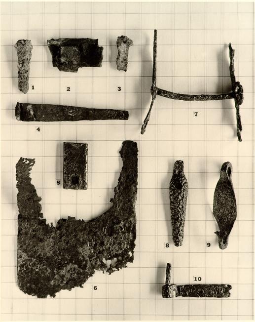 PLATE XXI. Iron Items from Various Deposits. 58-G.B.-1218.
PLATE XXI
- 1.Fragment from bayonet with triangular-sectioned blade, each face being markedly concave. A colonial form. E.R.55.
- 2.Fragment of an iron H-L hinges deliberately folded and probably intended for scrap. E.R.55.
- 3.Fragment from flat knife tang probably spreading into pistol grip at top, one brass rivet surviving as well as traces of the bone plates which flanked the tang. E.R.55.
- 4.Fragment of small strap hinge with U-shaped fragment, possibly from T-shaped jamb section. Three nail holes surviving on the strap and with part of a nail (now three-fourths of an inch) through one of them. E.R.71E.
- 5.Rectangular fragment of iron pierced by two square nail holes, thickness three-eighths of an inch maximum, the upper surface somewhat beveled. Part of ring unit attached to end of singletree on sagger(?) to which could be hooked a second team. [?] (Specimen 6.142.0.c.)
- 71
- 6.Fragmentary spade blade, iron, somewhat beveled at the corners, either intentionally or as the result of wear. The blade splitting towards the top to fit over and onto a wooden core. E.R.108.
- 7.Iron bit with triple ringed cheekpieces attached to a rigid, round-sectioned mouthpiece. An eighteenth century type. Unstratified. 13J4.
- 8.Sarcophagus-shaped iron object of uncertain purpose, concave on the reverse, a circular hole at the shoulder and with the head terminal slightly rising. Unstratified. 13J4.
- 9.Iron hook of unusual form, ring at one end spreading to a lozenge-shaped panel which in turn constricts and turns back on itself to form the hook, this last apparently spreading into a disc (?). Possibly related to carriage harness. Unstratified. 13J4.
- 10.Iron pintle of unusual form, roughly made and with flat bar in place of usual tang, the former pierced by two or more nail holes. Unstratified. Cat. No. 999-l3J4.
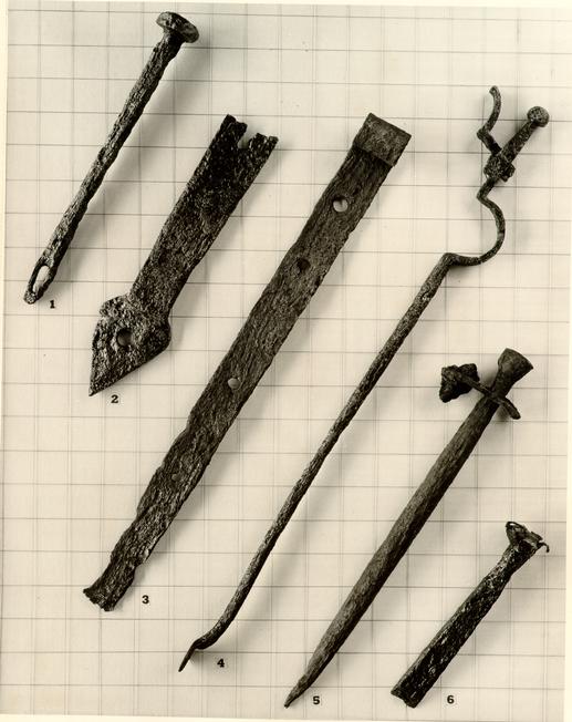 PLATE XXII. Iron Items from the Vicinity of the Scott Cellar. 1955 Excavations.
PLATE XXII
- 1.Large iron linchpin, disc-headed, square-sectioned and with eye at tapering and fifteen-sixteenths of an inch in length. Unstratified. Cat. No. 995-13J4.
- 2.Iron strap hinge, terminal fragment only, massive proportions, arrow-shaped terminal pierced by single, large nail hole. Thickness of strap at junction with terminal: one-half of an inch. The terminal thinner and stepped down. Unstratified. Cat. No. 996-13J4.
- 72
- 3.Strap hinge, large and crudely made, the socket for a pintle being roughly rolled, four nail holes of varying sizes surviving, terminal absent. Unstratified. Cat. No. 778-13J4.
- 4.Iron fire-tongs, one leg missing. Haft terminating in ball knop, the former slotted and recessed to hinge missing arm; surviving arm round-sectioned, ballooned below the hinge and terminating in a circular pad. Colonial. Unstratified. Cat. No. 1323-13J4.
- 5.Military tent peg, iron, round-sectioned, tapering to point at one end and to a constructed neck below a swelling head at the other. An iron loop of rectangular shape encircles the neck and to that the guys were attached. Unstratified. Cat. No. 1322-13J4.
- 6.Chisel of heavy iron, socketed at the top to take a wooden handle, now burred over as a result of long use without the protecting handle. Width of blade: seven-eighths of an inch. Unstratified. Cat. No. 132l-13J4.
Note: It is the opinion of Mr. J. M. Knight that the above items all came from the floor of the Scott cellar.
Footnotes
INDEX OF EXCAVATION REGISTER NUMBERS AND TABLE OF ARCHAEOLOGICAL DATING FOR STRATIFIED GROUPS
| Excavation Register No. | Dating | Page |
|---|---|---|
| 51 | Mid-l9th century | 27 |
| 52 | Mid-l9th century | 27, 28, 38 |
| 55 | c.1740-1760 | 26, 50 |
| 71A | c.1825-1850 | 10 |
| 71B | Early 19th century | 10, 12, 39, 49 |
| 71C | Early 19th century | 10, 12, 37, 38, 40, 44, 49 |
| 71D | Early 19th century | 10, 12, 37, 39, 40, 41, 43, 47, 49 |
| 71E | c.1776-1800 | 10, 45, 50 |
| 71F | 1776 | 11 14, 41, 42, 46, 50 |
| 72A | 1850-1900 | 12 |
| 72B | 19th to 20th century | 12 |
| 72C | Early 19th century | 12, 47, 49 40, 41, 42, 43, 44, 45, 47, 48 |
| 72D | Early 19th century | 13 |
| 72E | c.1776 | 13, 38, 41, 43, 47, 48 |
| 72F | 1776 | 13, 14, 38, 41, 43, 47, 48 |
| 72G | 1776 | 14, 42, 44 |
| 73 | c.1700-1770 | 34, 41 |
| 74 | c.1700-1770 | 34, 48 |
| 75 | Early 19th century | 34, 50 |
| 78 | 1820 or later | 23 |
| 79 | Unstratified | 39, 44, 47 |
| 74 | ||
| Excavation Register No. | Dating | Page |
| 82A-B | Post 1776 | 24, 45 |
| 83 | c.1820 | 18, 39 |
| 84A | c.1775-76 | 12, 14 |
| 84B | c.1717-1776 | 12 |
| 84C | c.1710-1720 (1717?) | 3, 12, 15, 46 |
| 85 | c.1770-1780 | 19 |
| 86 | c.1790 | 18 |
| 87 | c.1840 | 47 |
| 88 | c.1820 or later | 18, 38, 47, 50 |
| 91 | c.1780-1800 | 19, 42 |
| 92 | Modern | 43 |
| 93 | c.1775-1800 | 17 |
| 94 | c.1730-1760 | 36, 43 |
| 95 | c.1810 | 21 |
| 96 | c.1800-1810 | 20, 39, 41 |
| 97 | c.1770-1780 | 20, 41 |
| 98 | 1800-1850 | 30, 38, 45 |
| 99 | c.1770-1780 | 35, 37, 39, 40 |
| 103 | Late 18th century | 31, 28 |
| 104A | c.1830 or later | 25, 30, 44 |
| 104B | c.1810-1820 | 25, 30 |
| 106 | 18th century? | 24, 43 |
| 107 | 1750-1775 | 29, 43 |
| 108 | Late 18th century | 35, 50 |
| 109 | c.1770-1780 | 4, 29, 31, 35 |
| 110 | Mid-19th century | 24 |
| 111 | c.1760-1820 | 17 |
| 75 | ||
| Excavation Register No. | Dating | Page |
| 112 | c.1780-1830 | 17 |
| 113B | c.1800-1820* | 33 |
To: Mr. Riley
From: E. P. Alexander
Mr. Goodbody is working on a panel to be shown at the Peter Scott site. I understand that he is obtaining the site landscaping plan from Mr. Kendrew, and he would like to have the House History of the site and any other research information you may have. Perhaps you will wish to give him a call if there is a choice of materials. Otherwise, I should think you could send him the House History.
E. P. A.
Footnotes
Errata
Lektriever and Special Collections versions are in different order. Some pages and images even missing from Lektriever. For scanning purposes, the Special Collections contents and ordering were used.